IMAGES TAKEN NEAR TO
White Road, MARLBOROUGH, SN8 3HW
Introduction
This page details the photographs taken nearby to White Road, SN8 3HW by members of the Geograph project.
The Geograph project started in 2005 with the aim of publishing, organising and preserving representative images for every square kilometre of Great Britain, Ireland and the Isle of Man.

There are currently over 7.5m images from over14,400 individuals and you can help contribute to the project by visiting https://www.geograph.org.uk
Image Map (Loading...)


Getting Data...Please wait
Leaflet Map data © OpenStreetMap
Images are licensed for reuse under creativecommons.org/licenses/by-sa/2.0
Notes
- Clicking on the map will re-center to the selected point.
- The higher the marker number, the further away the image location is from the centre of the postcode.
Image Listing (15 Images Found)
Images are licensed for reuse under creativecommons.org/licenses/by-sa/2.0
Image
Details
Distance
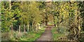
2

Speed Limit on the Bridleway
Church Walk, Savernake Forest, a public bridleway. Not sure who the speed limit is there for. Can you do 20 mph on a horse. Maybe.
Image: © Des Blenkinsopp
Taken: 10 Jul 2022
0.13 miles
3
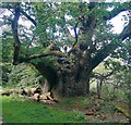
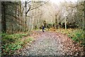
Savernake Forest, Wiltshire
Looking southeast along a track in Savernake Forest in the vicinity of Furze Coppice.
Image: © Rebecca A Wills
Taken: 17 Nov 2021
0.14 miles
4

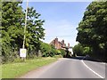
Old Toll House by the A4, Forest Hill
Forest Hill Toll House by the A4, in parish of Mildenhall (Kennet District), Forest Hill Lodge, Woodlands House, London Road, SN8.
Grade II listed.
List Entry Number: 1365483 https://historicengland.org.uk/listing/the-list/list-entry/1365483
Surveyed
Milestone Society National ID: WI.MIL
Image: © Alan Rosevear
Taken: Unknown
0.19 miles
6
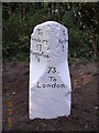
Old Milestone by the A4, London Road, Forest Hill
Bath Road limestone shoulders by the A4, in parish of Marlborough (Kennet District), Forest Hill; London Road opposite entrance to Marlborough Cricket & Hockey Club between Forest Hill Farm entrance and old Toll House, in undergrowth, 10m back from footpath.
Inscription reads:-
: To / Newbury / 17 / Hungerford / 8 : : 73 / To / London : : To / Marlbro / 2 :
Carved benchmark on East face.
Surveyed
Milestone Society National ID: WI_LB73
Image: © Milestone Society
Taken: 4 Sep 2004
0.19 miles
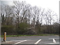
7
A4 in Forest Hill
Two older houses by the road on the edge of the village east of Marlborough
Image: © David Smith
Taken: 1 Jun 2017
0.20 miles
9
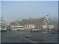
Savernake Hospital, Marlborough, Wiltshire
The original brick building has recently been extended by adding a steel and glass extension just visible to the left. The extension was funded in part by selling off some land at the rear for private housing.
Image: © Brian Robert Marshall
Taken: 22 Dec 2006
0.22 miles
10
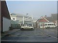
Savernake Hospital, Marlborough, Wiltshire
The glass and steel extension to the 19th century hospital was recently completed as a PFI (private finance initiative) project. The original brick-built hospital is a listed building.
Image: © Brian Robert Marshall
Taken: 22 Dec 2006
0.22 miles