IMAGES TAKEN NEAR TO
Whittonditch, MARLBOROUGH, SN8 2XB
Introduction
This page details the photographs taken nearby to Whittonditch, SN8 2XB by members of the Geograph project.
The Geograph project started in 2005 with the aim of publishing, organising and preserving representative images for every square kilometre of Great Britain, Ireland and the Isle of Man.

There are currently over 7.5m images from over14,400 individuals and you can help contribute to the project by visiting https://www.geograph.org.uk
Image Map (Loading...)


Getting Data...Please wait
Leaflet Map data © OpenStreetMap
Images are licensed for reuse under creativecommons.org/licenses/by-sa/2.0
Notes
- Clicking on the map will re-center to the selected point.
- The higher the marker number, the further away the image location is from the centre of the postcode.
Image Listing (11 Images Found)
Images are licensed for reuse under creativecommons.org/licenses/by-sa/2.0
Image
Details
Distance
1
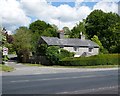
Cottage at Whittonditch
I was puzzled by the building material used here. I had to look quite closely to convince myself that it was pale grey brick, rather than stone.
The cottage stands by the B4192 Swindon-Hungerford road.
Image: © Stefan Czapski
Taken: 6 Jun 2019
0.04 miles
2
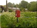
Whittonditch: postbox № SN8 105
A small postbox sharing a field gateway with the bus stop shown in Image It is emptied at 4:45pm on weekdays and at 8:45am on Saturdays.
Image: © Chris Downer
Taken: 1 Jun 2010
0.07 miles
3
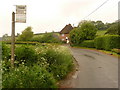
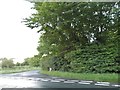
Whittonditch: cottage and bus stop
The view immediately having turned off the main road into the lane heading for Ramsbury.
Image: © Chris Downer
Taken: 1 Jun 2010
0.09 miles
4
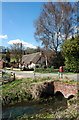
Cottage at Whittonditch
This thatched cottage is in the hamlet of Whittonditch.
The river is the Aldbourne.
Image: © Des Blenkinsopp
Taken: 8 Apr 2010
0.12 miles
5
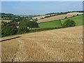
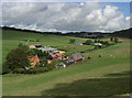
Farmland above Whittonditch
A view up the Aldbourne valley from the footpath east of the hamlet
Image: © Andrew Smith
Taken: 20 Sep 2008
0.16 miles
8
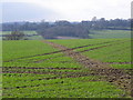
Footpath near Whittonditch
The footpath crosses arable fields to the village of Whittonditch.
Image: © Maigheach-gheal
Taken: 5 Mar 2011
0.22 miles
9
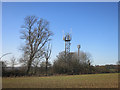
Whittonside
The valley leading up to Witcha and to the west of Membury, where the transmitter can be seen.
Image: © Andrew Smith
Taken: 2 Oct 2006
0.24 miles
10
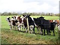
Cattle, Whittonditch
An interested bunch of cattle take a look at me while I take a couple of photos in the square.
Image: © Maigheach-gheal
Taken: 22 Nov 2009
0.24 miles