IMAGES TAKEN NEAR TO
The Paddocks, MARLBOROUGH, SN8 2QF
Introduction
This page details the photographs taken nearby to The Paddocks, SN8 2QF by members of the Geograph project.
The Geograph project started in 2005 with the aim of publishing, organising and preserving representative images for every square kilometre of Great Britain, Ireland and the Isle of Man.

There are currently over 7.5m images from over14,400 individuals and you can help contribute to the project by visiting https://www.geograph.org.uk
Image Map
Images are licensed for reuse under creativecommons.org/licenses/by-sa/2.0
Notes
- Clicking on the map will re-center to the selected point.
- The higher the marker number, the further away the image location is from the centre of the postcode.
Image Listing (90 Images Found)
Images are licensed for reuse under creativecommons.org/licenses/by-sa/2.0
Image
Details
Distance
1
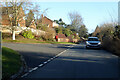
Junction of The Paddocks and Newtown Road, Ramsbury
Postbox SN8 149 on the corner.
Image: © Robin Webster
Taken: 13 Jan 2023
0.04 miles
2
![Ramsbury houses [52]](https://s1.geograph.org.uk/geophotos/06/44/96/6449661_74b202d9_120x120.jpg)
Ramsbury houses [52]
Seen from Union Street is this glimpse of Vine Cottage. Originally three cottages, now all one house. The first part of the building, 2 bays, is 17th century with the other four bays added later. Listed, grade II, with details at: https://historicengland.org.uk/listing/the-list/list-entry/1034063
Ramsbury lies in fertile farming land in the valley of the River Kennet. The site has been occupied since at least the Iron Age and there are several Roman villas. There was a bishopric of Ramsbury, established by 909 and ended in 1075 when it was included in the bishopric of Salisbury. Until 1744 when the present A4 road was turnpiked, the road through the village was part of the main route from London to Bristol.
Image: © Michael Dibb
Taken: 14 Mar 2020
0.08 miles
3
![Ramsbury houses [50]](https://s2.geograph.org.uk/geophotos/06/44/96/6449658_5401199a_120x120.jpg)
Ramsbury houses [50]
This pair of semi-detached houses in diaper brickwork at numbers 4 and 5 Union Street has a central datestone of 1833.
Ramsbury lies in fertile farming land in the valley of the River Kennet. The site has been occupied since at least the Iron Age and there are several Roman villas. There was a bishopric of Ramsbury, established by 909 and ended in 1075 when it was included in the bishopric of Salisbury. Until 1744 when the present A4 road was turnpiked, the road through the village was part of the main route from London to Bristol.
Image: © Michael Dibb
Taken: 14 Mar 2020
0.09 miles
4
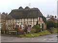
Whittonditch Road, Ramsbury
Picturesque thatched cottage with an interesting mix of stonework, brick and half-timbering.
www.ramsbury.org
Image: © Colin Smith
Taken: 1 Feb 2011
0.09 miles
5
![Ramsbury houses [51]](https://s0.geograph.org.uk/geophotos/06/44/96/6449660_024e7321_120x120.jpg)
Ramsbury houses [51]
The thatched Hollyhock Cottage in Union Street is tucked away behind its garage.
Ramsbury lies in fertile farming land in the valley of the River Kennet. The site has been occupied since at least the Iron Age and there are several Roman villas. There was a bishopric of Ramsbury, established by 909 and ended in 1075 when it was included in the bishopric of Salisbury. Until 1744 when the present A4 road was turnpiked, the road through the village was part of the main route from London to Bristol.
Image: © Michael Dibb
Taken: 14 Mar 2020
0.09 miles
7
![Ramsbury houses [53]](https://s3.geograph.org.uk/geophotos/06/44/96/6449663_a6526be5_120x120.jpg)
Ramsbury houses [53]
Smithy Cottage in Union Street is probably earlier than the 19th century. Built in a mixture of flint and brick with a thatched roof. Listed, grade II, with details at: https://historicengland.org.uk/listing/the-list/list-entry/1184010
Ramsbury lies in fertile farming land in the valley of the River Kennet. The site has been occupied since at least the Iron Age and there are several Roman villas. There was a bishopric of Ramsbury, established by 909 and ended in 1075 when it was included in the bishopric of Salisbury. Until 1744 when the present A4 road was turnpiked, the road through the village was part of the main route from London to Bristol.
Image: © Michael Dibb
Taken: 14 Mar 2020
0.09 miles
8
![The River Kennet [1]](https://s3.geograph.org.uk/geophotos/06/44/97/6449727_0b4f98ad_120x120.jpg)
The River Kennet [1]
The river is seen, looking downstream, from the bridge that carries the road south to Froxfield and Chisbury. One of the sources is Swallowhead Spring near Silbury Hill, the other being a collection of tributaries north of Avebury. The river flows through Marlborough, Hungerford and Newbury before flowing into the Thames near Sonning Lock at Reading in Berkshire.
Ramsbury lies in fertile farming land in the valley of the River Kennet. The site has been occupied since at least the Iron Age and there are several Roman villas. There was a bishopric of Ramsbury, established by 909 and ended in 1075 when it was included in the bishopric of Salisbury. Until 1744 when the present A4 road was turnpiked, the road through the village was part of the main route from London to Bristol.
Image: © Michael Dibb
Taken: 14 Mar 2020
0.09 miles
9
![Ramsbury houses [49]](https://s0.geograph.org.uk/geophotos/06/44/96/6449656_237348b9_120x120.jpg)
Ramsbury houses [49]
Lamorna Cottage in Whittonditch Road is 17th century part brick and part timber framed with a thatched roof. Originally one storey, raised to two storeys later.
Listed, grade II, with details at: https://historicengland.org.uk/listing/the-list/list-entry/1034066
Ramsbury lies in fertile farming land in the valley of the River Kennet. The site has been occupied since at least the Iron Age and there are several Roman villas. There was a bishopric of Ramsbury, established by 909 and ended in 1075 when it was included in the bishopric of Salisbury. Until 1744 when the present A4 road was turnpiked, the road through the village was part of the main route from London to Bristol.
Image: © Michael Dibb
Taken: 14 Mar 2020
0.09 miles
10
![Ramsbury houses [54]](https://s1.geograph.org.uk/geophotos/06/44/97/6449717_caa525f9_120x120.jpg)
Ramsbury houses [54]
The Knap House is 18th century in vitrified brick. Listed, grade II, with details at: https://historicengland.org.uk/listing/the-list/list-entry/1183861
Ramsbury lies in fertile farming land in the valley of the River Kennet. The site has been occupied since at least the Iron Age and there are several Roman villas. There was a bishopric of Ramsbury, established by 909 and ended in 1075 when it was included in the bishopric of Salisbury. Until 1744 when the present A4 road was turnpiked, the road through the village was part of the main route from London to Bristol.
Image: © Michael Dibb
Taken: 14 Mar 2020
0.10 miles