IMAGES TAKEN NEAR TO
Mildenhall, MARLBOROUGH, SN8 2NL
Introduction
This page details the photographs taken nearby to SN8 2NL by members of the Geograph project.
The Geograph project started in 2005 with the aim of publishing, organising and preserving representative images for every square kilometre of Great Britain, Ireland and the Isle of Man.

There are currently over 7.5m images from over14,400 individuals and you can help contribute to the project by visiting https://www.geograph.org.uk
Image Map (Loading...)


Getting Data...Please wait
Leaflet Map data © OpenStreetMap
Images are licensed for reuse under creativecommons.org/licenses/by-sa/2.0
Notes
- Clicking on the map will re-center to the selected point.
- The higher the marker number, the further away the image location is from the centre of the postcode.
Image Listing (9 Images Found)
Images are licensed for reuse under creativecommons.org/licenses/by-sa/2.0
Image
Details
Distance
1
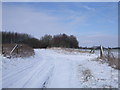
Byway, Poulton Downs
The byway to Bytham Farm is joined here by the farm track from Warren Farm. The tyre tracks were made by the post van earlier in the day.
Image: © Vieve Forward
Taken: 10 Feb 2012
0.15 miles
2
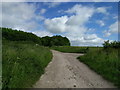
Lane junction on the old Roman road, Greenway Road
Image: © Rob Purvis
Taken: 10 Jun 2017
0.15 miles
3
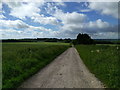
Roman road, Greenway Road, heading south through farmland
Image: © Rob Purvis
Taken: 10 Jun 2017
0.16 miles
4
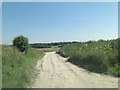
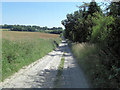
Bytham Road junction to Swains Cottage
This is a Roman Road! The Bytham appellation probably dates from the 17th C. In 1691 an estate known as Bytham, probably newly enclosed in 1690 and measuring some 147 acres, was held by Gabriel Evans and this track leads to the farm of the same name. However; the A346 which tracks south from Swindon was part of a Roman Road between Cirencester and Winchester. When the road was turnpiked in the 18th C this part was left unmetalled heading south to Mildenhall and the turnpike re-routed further west. See:http://history.wiltshire.gov.uk/community/getcom.php?id=178
Image: © Stuart Logan
Taken: 24 Jul 2012
0.16 miles
5
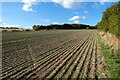
Farmland, Mildenhall
A short stretch of byway cuts across the field here but there are only faint signs of its use.
Image: © Andrew Smith
Taken: 8 Oct 2022
0.16 miles
6
Bytham Road south of Bytham Farm
This is a Roman Road! The Bytham appellation probably dates from the 17th C. In 1691 an estate known as Bytham, probably newly enclosed in 1690 and measuring some 147 acres, was held by Gabriel Evans and this track leads to the farm of the same name. However; the A346 which tracks south from Swindon was part of a Roman Road between Cirencester and Winchester. When the road was turnpiked in the 18th C this part was left unmetalled heading south to Mildenhall and the turnpike re-routed further west. See:http://history.wiltshire.gov.uk/community/getcom.php?id=178
Image: © Stuart Logan
Taken: 24 Jul 2012
0.22 miles
7
Warren Farm
A clutter of farm buildings that look even untidier close up.
Image: © Vieve Forward
Taken: 10 Feb 2012
0.22 miles
8
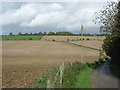
Fields, Warren Farm
On the drive (and bridleway) leading to Warren Cottage.
Image: © Andrew Smith
Taken: 21 Oct 2006
0.23 miles
9
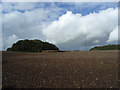
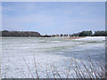
Farmland and copse, Mildenhall Warren
The small square copse on the southern edge of the grid-square.
Image: © Andrew Smith
Taken: 21 Oct 2006
0.24 miles