IMAGES TAKEN NEAR TO
Aldbourne, MARLBOROUGH, SN8 2JZ
Introduction
This page details the photographs taken nearby to SN8 2JZ by members of the Geograph project.
The Geograph project started in 2005 with the aim of publishing, organising and preserving representative images for every square kilometre of Great Britain, Ireland and the Isle of Man.

There are currently over 7.5m images from over14,400 individuals and you can help contribute to the project by visiting https://www.geograph.org.uk
Image Map (Loading...)


Getting Data...Please wait
Leaflet Map data © OpenStreetMap
Images are licensed for reuse under creativecommons.org/licenses/by-sa/2.0
Notes
- Clicking on the map will re-center to the selected point.
- The higher the marker number, the further away the image location is from the centre of the postcode.
Image Listing (3 Images Found)
Images are licensed for reuse under creativecommons.org/licenses/by-sa/2.0
Image
Details
Distance
1
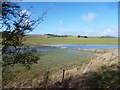
The Aldbourne in the fields
High groundwater levels after a very wet winter have caused a large amount of water to flow in this usually dry valley.
Image: © Des Blenkinsopp
Taken: 22 Feb 2014
0.09 miles
2
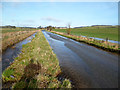
The Aldbourne near North Field Barn 3
High groundwater levels after a very wet winter have caused a large amount of water to flow in this usually dry valley.
The small roadside ditch has been overwhelmed and the river is in the fields and in the road.
Image: © Des Blenkinsopp
Taken: 22 Feb 2014
0.18 miles
3
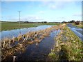
The Aldbourne near North Field Barn 1
High groundwater levels after a very wet winter have caused a large amount of water to flow in this usually dry valley.
The small roadside ditch has been overwhelmed and the river is in the fields and in the road.
Image: © Des Blenkinsopp
Taken: 22 Feb 2014
0.24 miles