IMAGES TAKEN NEAR TO
The Green, MARLBOROUGH, SN8 2JW
Introduction
This page details the photographs taken nearby to The Green, SN8 2JW by members of the Geograph project.
The Geograph project started in 2005 with the aim of publishing, organising and preserving representative images for every square kilometre of Great Britain, Ireland and the Isle of Man.

There are currently over 7.5m images from over14,400 individuals and you can help contribute to the project by visiting https://www.geograph.org.uk
Image Map (40 Images)


Getting Data...Please wait
Leaflet Map data © OpenStreetMap
Images are licensed for reuse under creativecommons.org/licenses/by-sa/2.0
Notes
- Clicking on the map will re-center to the selected point.
- The higher the marker number, the further away the image location is from the centre of the postcode.
Image Listing (40 Images Found)
Images are licensed for reuse under creativecommons.org/licenses/by-sa/2.0
Image
Details
Distance
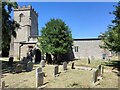
1
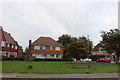
Cottages in Baydon
Flint cottages with bands of brick facing on to the small village green with its laburnum tree. The tower of St Nicholas is visible between the cottages.
Image: © Colin Smith
Taken: 23 May 2008
0.01 miles
5

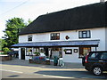
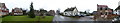
Sign on Baydon village store and post office
Image: © Nick Smith
Taken: 30 Jun 2008
0.02 miles
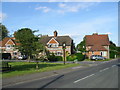
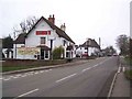
6
The Red Lion, Baydon, on Ermin Street - the B4000
Image: © Nick Smith
Taken: 30 Jun 2008
0.02 miles
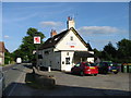
7
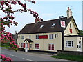
Baydon, Red Lion
Village pub, with Britain's commonest pub name, at the crossroads on Ermin Street, a former Roman road.
Image: © Colin Smith
Taken: 23 May 2008
0.03 miles