IMAGES TAKEN NEAR TO
Baydon, MARLBOROUGH, SN8 2JB
Introduction
This page details the photographs taken nearby to SN8 2JB by members of the Geograph project.
The Geograph project started in 2005 with the aim of publishing, organising and preserving representative images for every square kilometre of Great Britain, Ireland and the Isle of Man.

There are currently over 7.5m images from over14,400 individuals and you can help contribute to the project by visiting https://www.geograph.org.uk
Image Map (Loading...)


Getting Data...Please wait
Leaflet Map data © OpenStreetMap
Images are licensed for reuse under creativecommons.org/licenses/by-sa/2.0
Notes
- Clicking on the map will re-center to the selected point.
- The higher the marker number, the further away the image location is from the centre of the postcode.
Image Listing (16 Images Found)
Images are licensed for reuse under creativecommons.org/licenses/by-sa/2.0
Image
Details
Distance
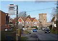
1
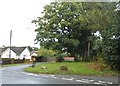
Aldbourne Road at the junction of Barley Fields
Image: © David Howard
Taken: 30 Jul 2017
0.11 miles
2
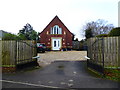
Former chapel, Baydon
Former Methodist chapel, dated 1939.
Image: © Vieve Forward
Taken: 29 Dec 2019
0.15 miles
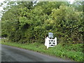
4
Entrance to bridleway near Baydon House Farm
Image: © Vieve Forward
Taken: 29 Dec 2019
0.22 miles
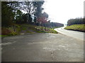
7
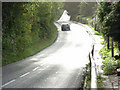
Ermin Street, Baydon
The Roman road east of the village centre. I'm guessing, without having checked it on the map, that it linked Silchester and Cirencester.
Image: © Andrew Smith
Taken: 1 Oct 2006
0.22 miles
9
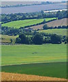
A slice of Wiltshire
Various crops, grass fields and paddocks are represented.
Image: © Edmund Shaw
Taken: 2 Aug 2015
0.24 miles
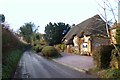
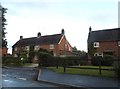
10
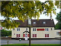
The Red Lion
Village pub in Baydon, seen from the green. The pub sits on Ermin Street - a long and straight stretch following the former Roman road. Flowering laburnum and village sign are also visible.
Image: © Colin Smith
Taken: 23 May 2008
0.24 miles