IMAGES TAKEN NEAR TO
Axford, MARLBOROUGH, SN8 2HA
Introduction
This page details the photographs taken nearby to SN8 2HA by members of the Geograph project.
The Geograph project started in 2005 with the aim of publishing, organising and preserving representative images for every square kilometre of Great Britain, Ireland and the Isle of Man.

There are currently over 7.5m images from over14,400 individuals and you can help contribute to the project by visiting https://www.geograph.org.uk
Image Map
Images are licensed for reuse under creativecommons.org/licenses/by-sa/2.0
Notes
- Clicking on the map will re-center to the selected point.
- The higher the marker number, the further away the image location is from the centre of the postcode.
Image Listing (20 Images Found)
Images are licensed for reuse under creativecommons.org/licenses/by-sa/2.0
Image
Details
Distance
1
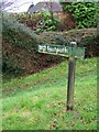
Footpath sign, Axford
The footpath indicates that there are stiles to be crossed.
Image: © Maigheach-gheal
Taken: 22 Nov 2009
0.04 miles
2
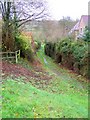
Footpath, Axford
The narrow footpath passes between houses on its way to cross the River Kennet.
Image: © Maigheach-gheal
Taken: 22 Nov 2009
0.05 miles
5
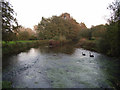
The River Kennet
Two black swans, presumably escaped from captivity, drifting downstream.
Image: © Andrew Smith
Taken: 15 Oct 2006
0.14 miles
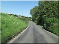
6
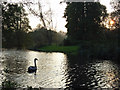
The River Kennet
Where crossed by the footpath to the south of Axford village.
Image: © Andrew Smith
Taken: 15 Oct 2006
0.14 miles
8
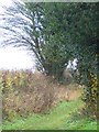
Bridleway, Axford
The bridleway takes walkers and riders towards Sound Bottom.
Image: © Maigheach-gheal
Taken: 22 Nov 2009
0.16 miles
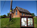
9
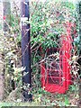
Telephone box, Axford
A K6 type telephone hides in the undergrowth beside the bus shelter.
Image: © Maigheach-gheal
Taken: 22 Nov 2009
0.16 miles
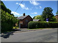
10
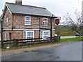
The Red Lion Inn, Axford
Traditional 16th century brick and flint building.
Image: © Maigheach-gheal
Taken: 22 Nov 2009
0.17 miles