IMAGES TAKEN NEAR TO
Upper Upham, Aldbourne, MARLBOROUGH, SN8 2FT
Introduction
This page details the photographs taken nearby to SN8 2FT by members of the Geograph project.
The Geograph project started in 2005 with the aim of publishing, organising and preserving representative images for every square kilometre of Great Britain, Ireland and the Isle of Man.

There are currently over 7.5m images from over14,400 individuals and you can help contribute to the project by visiting https://www.geograph.org.uk
Image Map (Loading...)


Getting Data...Please wait
Leaflet Map data © OpenStreetMap
Images are licensed for reuse under creativecommons.org/licenses/by-sa/2.0
Notes
- Clicking on the map will re-center to the selected point.
- The higher the marker number, the further away the image location is from the centre of the postcode.
Image Listing (14 Images Found)
Images are licensed for reuse under creativecommons.org/licenses/by-sa/2.0
Image
Details
Distance
1
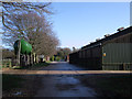
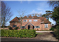
Upham Farm, Upper Upham
Farming has taken place around Upham Farm at least since the Bronze Age, if not earlier, and in the field opposite the farm buildings, earthworks belonging to ancient field systems dating back to medieval and possibly prehistoric times can still be seen. It is now a mixed farm.
Image: © Vieve Forward
Taken: 27 Jan 2012
0.02 miles
2
Modern houses, Upper Upham
Judging by their proximity to the farm, these smaller modern houses in Upper Upham were probably designated for farm workers.http://www.bbc.co.uk/history/domesday/dblock/GB-420000-177000/page/9
Image: © Vieve Forward
Taken: 27 Jan 2012
0.02 miles
3
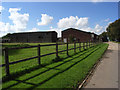
Upham Farm
At the end of the tarmac road which continues as a byway.
Image: © Andrew Smith
Taken: 24 Sep 2006
0.03 miles
4
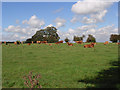
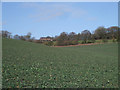
Cattle. Upper Upham
Grazing on the site of Upham village.
Image: © Andrew Smith
Taken: 24 Sep 2006
0.03 miles
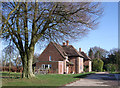
5
The Coach House, Upper Upham
Renovated coach house in Upper Upham.http://www.bbc.co.uk/history/domesday/dblock/GB-420000-177000/page/9
Image: © Vieve Forward
Taken: 27 Jan 2012
0.03 miles
6
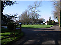
Houses, Upper Upham
Six modern detached houses were built in Upper Upham in the 1960s to recreate a feudal village round a green.http://www.bbc.co.uk/history/domesday/dblock/GB-420000-177000/page/9
Image: © Vieve Forward
Taken: 27 Jan 2012
0.06 miles
7
Upper Upham from the south
Turning to look back from the bridlepath to Snap, Upper Upham sits aloof on top of the hill.
Image: © Vieve Forward
Taken: 27 Jan 2012
0.08 miles
8
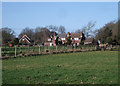
Modern houses in Upper Upham
This crescent of large modern houses in Upper Upham is situated between the farm and paddocks in which horses graze. Note the solar heating panels on the roof of the nearest house.
Image: © Vieve Forward
Taken: 27 Jan 2012
0.09 miles
9
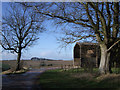
Barn, Upper Upham
Beside the byway where a private track goes off to the north.
Image: © Andrew Smith
Taken: 24 Sep 2006
0.15 miles
10
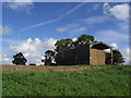
Barn, Upper Upham
Barn at the edge of Upper Upham. Muttondown plantation can be seen on the horizon.
Image: © Vieve Forward
Taken: 27 Jan 2012
0.16 miles