IMAGES TAKEN NEAR TO
Lottage Road, MARLBOROUGH, SN8 2EB
Introduction
This page details the photographs taken nearby to Lottage Road, SN8 2EB by members of the Geograph project.
The Geograph project started in 2005 with the aim of publishing, organising and preserving representative images for every square kilometre of Great Britain, Ireland and the Isle of Man.

There are currently over 7.5m images from over14,400 individuals and you can help contribute to the project by visiting https://www.geograph.org.uk
Image Map
Images are licensed for reuse under creativecommons.org/licenses/by-sa/2.0
Notes
- Clicking on the map will re-center to the selected point.
- The higher the marker number, the further away the image location is from the centre of the postcode.
Image Listing (59 Images Found)
Images are licensed for reuse under creativecommons.org/licenses/by-sa/2.0
Image
Details
Distance
1
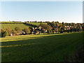
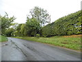
Aldbourne
The northern end of the village, with Baydon Hill Farm above.
Image: © Andrew Smith
Taken: 24 Oct 2006
0.05 miles
2
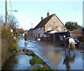
Groundwater Flooding in Aldbourne 4
This is Lottage Road in Aldbourne which has been closed to traffic due to the River Aldbourne flowing along it. Not a problem for these horse riders though.
In the foreground is the official river channel which as you see is unable to cope with the large amount of water coming down from the normally dry upper section of the valley.
Water is also pouring out of drains and springs all along the road itself.
Image: © Des Blenkinsopp
Taken: 22 Feb 2014
0.11 miles
3
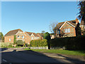
Modern brick and flint houses, Aldbourne
In Chandler's Lane, off Lottage Road.
Image: © Andrew Smith
Taken: 24 Oct 2006
0.11 miles
4
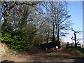
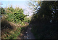
Entrance to Bridleway to Four Barrows, Aldbourne
This muddy bridleway, popular with dog walkers, leads north from Aldbourne to the summit of the down and thence to Four Barrows and beyond.
Image: © Vieve Forward
Taken: 27 Jan 2012
0.14 miles
6
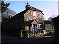
Candlemas Cottage, Aldbourne
This cottage near the church at Aldbourne was built using traditional materials: brick made with clay from the Kennet valley, and sarsen sandstone from the Downs.
Image: © Vieve Forward
Taken: 27 Jan 2012
0.19 miles
7
Bridleway northwest out of Aldbourne
This muddy bridleway climbs steeply between high hedgerows up on to the down.
Image: © Vieve Forward
Taken: 27 Jan 2012
0.19 miles
8
St Michael, Aldbourne: mid February 2024
Image: © Basher Eyre
Taken: 16 Feb 2024
0.19 miles
9
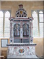
Walrond Monument, Aldbourne Church
Classical Renaissance monument to the brothers Walrond who died in 1614 and 1617. They were related to the Goddard family who have memorials inside St Michael's too.
http://aldbourne.net/
Image: © Colin Smith
Taken: 1 Feb 2011
0.20 miles
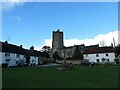
10
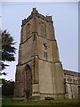
Aldbourne Church Tower
Mighty 15th century tower, with fine window, at the west end of St Michael, Aldbourne's parish church.
http://aldbourne.net/
Image: © Colin Smith
Taken: 1 Feb 2011
0.20 miles