IMAGES TAKEN NEAR TO
Oxford Street, MARLBOROUGH, SN8 2DG
Introduction
This page details the photographs taken nearby to Oxford Street, SN8 2DG by members of the Geograph project.
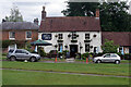
The Geograph project started in 2005 with the aim of publishing, organising and preserving representative images for every square kilometre of Great Britain, Ireland and the Isle of Man.

There are currently over 7.5m images from over14,400 individuals and you can help contribute to the project by visiting https://www.geograph.org.uk
Image Map (Loading...)


Getting Data...Please wait
Leaflet Map data © OpenStreetMap
Images are licensed for reuse under creativecommons.org/licenses/by-sa/2.0
Notes
- Clicking on the map will re-center to the selected point.
- The higher the marker number, the further away the image location is from the centre of the postcode.
Image Listing (100 Images Found)
Images are licensed for reuse under creativecommons.org/licenses/by-sa/2.0
Image
Details
Distance
1
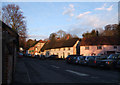
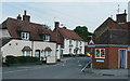
Traditional cottages, Oxford Street, Aldbourne
Traditional thatched cottages built of flint and brick are highlighted by the evening sun.
Image: © Vieve Forward
Taken: 27 Jan 2012
0.05 miles
2
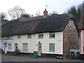
Oxford Street, Aldbourne
Fine old thatched cottages, built of stone, face onto the rectangular village green.
http://aldbourne.net/
Image: © Colin Smith
Taken: 1 Feb 2011
0.06 miles
3
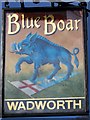
Sign for the Blue Boar
The blue boar is a heraldic reference to the Earl of Oxford. The white boar similarly refers to Richard III. It is said that after the defeat of Richard and the Yorkists at the Battle of Bosworth (1485), many White Boar signs were hastily painted blue, since the Earl of Oxford was a leading supporter of the Lancastrain cause.
Image: © Maigheach-gheal
Taken: 22 Nov 2009
0.08 miles
4
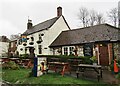
Aldbourne - The Blue Boar
One of two pubs in the large Wiltshire village of Aldbourne.
www.aldbourne.net
Image: © Colin Smith
Taken: 28 Feb 2020
0.08 miles
5
The Blue Boar, Aldbourne
The Blue boar is a Wadworth's pub occupying an enviable position on the village green. It featured in a Doctor Who story, filmed in 1971, as the 'Cloven Hoof'.
Image: © Stephen McKay
Taken: 22 Jun 2021
0.08 miles
6
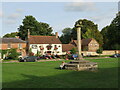
Village Green, Aldbourne
Pleasant open space with an old village cross, the base being medieval, whilst the column is 18thC. Grade II listed.
Image: © Gordon Hatton
Taken: 25 Sep 2022
0.08 miles
7
Aldbourne village centre
A nuclear (in the geographical sense) village in a fine valley-bottom position mid-way between Swindon and Hungerford.
See; http://www.aldbourne.org.uk/awg/portal/main/welcome.asp
Image: © Jonathan Billinger
Taken: 22 May 2008
0.08 miles
8
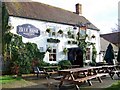
The Blue Boar, Aldbourne
There are records of The Blue Boar at the east of The Green by name from 1822. The pub was closed in 1911 but re-opened in or before 1931.
Image: © Maigheach-gheal
Taken: 22 Nov 2009
0.09 miles
9
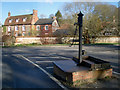
The Village Pump
This old pump is a bit of a traffic hazard sited in the middle of a road junction. As you can see, the top is bent due to a collision. When I took this shot the top was dislodged and I could lower a tape into the well underneath, which is about 10 metres deep. I think it has been repaired now. Until the next time. The Aldbourne flows by the wall in front of the house.
Image: © Des Blenkinsopp
Taken: 16 Dec 2007
0.09 miles
10
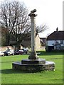
Cross, Aldbourne
The cross stands on the green between St Michael's Church and the Blue Boar public house.
Image: © Maigheach-gheal
Taken: 22 Nov 2009
0.09 miles