IMAGES TAKEN NEAR TO
Cornerfield, MARLBOROUGH, SN8 2BN
Introduction
This page details the photographs taken nearby to Cornerfield, SN8 2BN by members of the Geograph project.
The Geograph project started in 2005 with the aim of publishing, organising and preserving representative images for every square kilometre of Great Britain, Ireland and the Isle of Man.

There are currently over 7.5m images from over14,400 individuals and you can help contribute to the project by visiting https://www.geograph.org.uk
Image Map
Images are licensed for reuse under creativecommons.org/licenses/by-sa/2.0
Notes
- Clicking on the map will re-center to the selected point.
- The higher the marker number, the further away the image location is from the centre of the postcode.
Image Listing (50 Images Found)
Images are licensed for reuse under creativecommons.org/licenses/by-sa/2.0
Image
Details
Distance
1
![Marlborough features [13]](https://s2.geograph.org.uk/geophotos/05/46/87/5468750_235e9402_120x120.jpg)
Marlborough features [13]
The recreation ground is seen from Elcot Lane. The stone commemorates the granting of Village Green status in 2006.
Marlborough is a market town on the Old Bath Road once the main road from London to Bath. The twice-weekly market is sited in High Street, one of the widest in England, lined on both sides with fine listed buildings of which the town has almost 300. There is evidence of local settlement from every period from the prehistoric to the present day. The town is home to the renowned Marlborough College. The River Kennet flows through the town.
Image: © Michael Dibb
Taken: 17 Jul 2017
0.10 miles
2
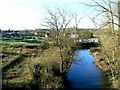
A view of the River Kennet, Marlborough, Wiltshire
This is a view upstream. Marlborough waste water treatment works is the left. Clean effluent from the works is discharged into the river at this point.
Image: © Brian Robert Marshall
Taken: 16 Dec 2006
0.13 miles
3
![Marlborough ways [18]](https://s3.geograph.org.uk/geophotos/05/46/87/5468751_717db40c_120x120.jpg)
Marlborough ways [18]
From Elcot Lane this short footpath runs to London Road (A4).
Marlborough is a market town on the Old Bath Road once the main road from London to Bath. The twice-weekly market is sited in High Street, one of the widest in England, lined on both sides with fine listed buildings of which the town has almost 300. There is evidence of local settlement from every period from the prehistoric to the present day. The town is home to the renowned Marlborough College. The River Kennet flows through the town.
Image: © Michael Dibb
Taken: 17 Jul 2017
0.14 miles
4
![Marlborough features [14]](https://s0.geograph.org.uk/geophotos/05/46/87/5468752_85bc0122_120x120.jpg)
Marlborough features [14]
The well fenced sewage works for the town are off Elcot Lane. Many signs warn of the dangers of deep water and of moving machinery.
Marlborough is a market town on the Old Bath Road once the main road from London to Bath. The twice-weekly market is sited in High Street, one of the widest in England, lined on both sides with fine listed buildings of which the town has almost 300. There is evidence of local settlement from every period from the prehistoric to the present day. The town is home to the renowned Marlborough College. The River Kennet flows through the town.
Image: © Michael Dibb
Taken: 17 Jul 2017
0.14 miles
5
![Marlborough ways [14]](https://s1.geograph.org.uk/geophotos/05/46/87/5468749_e0787e9e_120x120.jpg)
Marlborough ways [14]
Behind the fence are Elcot Lane Allotments. Along the track is Marlborough Town Football Club who play in the Wiltshire Senior Football League – Premier Division.
Marlborough is a market town on the Old Bath Road once the main road from London to Bath. The twice-weekly market is sited in High Street, one of the widest in England, lined on both sides with fine listed buildings of which the town has almost 300. There is evidence of local settlement from every period from the prehistoric to the present day. The town is home to the renowned Marlborough College. The River Kennet flows through the town.
Image: © Michael Dibb
Taken: 17 Jul 2017
0.14 miles
6
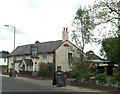
The Roebuck
Dating back several hundred years as a coaching inn beside the Bath Road this pub is now a Fullers tied house.
Image: © Stuart Logan
Taken: 15 May 2011
0.16 miles
7
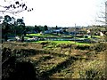
Waste water treatment works, Marlborough, Wiltshire
Unglamorous but essential. The main features visible are the circular filter beds that clean the water after primary settlement has taken place.
Image: © Brian Robert Marshall
Taken: 16 Dec 2006
0.17 miles
8
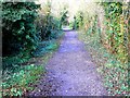
Looking north along the Sustrans cycle path, Marlborough
Once this was route of the Midland and South Western Junction Railway that closed in 1961. Now part of the National cycle network.
Image: © Brian Robert Marshall
Taken: 16 Dec 2006
0.17 miles
9
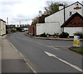
Western end of Elcot Lane, Marlborough
Looking east along Elcot Lane from the corner of London Road.
The Fuller's name on the right is on a wall of the Roebuck Inn. http://www.geograph.org.uk/photo/5568727
Image: © Jaggery
Taken: 14 Oct 2017
0.18 miles
10
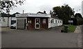
Marlborough Veterinary Surgery, 51 London Road, Marlborough
A branch surgery of Drove Veterinary Hospital.
Image: © Jaggery
Taken: 14 Oct 2017
0.18 miles