IMAGES TAKEN NEAR TO
Hazel Close, MARLBOROUGH, SN8 2AD
Introduction
This page details the photographs taken nearby to Hazel Close, SN8 2AD by members of the Geograph project.
The Geograph project started in 2005 with the aim of publishing, organising and preserving representative images for every square kilometre of Great Britain, Ireland and the Isle of Man.

There are currently over 7.5m images from over14,400 individuals and you can help contribute to the project by visiting https://www.geograph.org.uk
Image Map
Images are licensed for reuse under creativecommons.org/licenses/by-sa/2.0
Notes
- Clicking on the map will re-center to the selected point.
- The higher the marker number, the further away the image location is from the centre of the postcode.
Image Listing (41 Images Found)
Images are licensed for reuse under creativecommons.org/licenses/by-sa/2.0
Image
Details
Distance
1
![Marlborough ways [24]](https://s0.geograph.org.uk/geophotos/05/46/98/5469880_863887ed_120x120.jpg)
Marlborough ways [24]
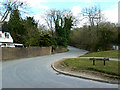
This private road is called Barnfield.
Marlborough is a market town on the Old Bath Road once the main road from London to Bath. The twice-weekly market is sited in High Street, one of the widest in England, lined on both sides with fine listed buildings of which the town has almost 300. There is evidence of local settlement from every period from the prehistoric to the present day. The town is home to the renowned Marlborough College. The River Kennet flows through the town.
Image: © Michael Dibb
Taken: 17 Jul 2017
0.05 miles
2
![Marlborough ways [25]](https://s1.geograph.org.uk/geophotos/05/46/98/5469881_f6d20a18_120x120.jpg)
Marlborough ways [25]
Braemore Lodge is located in the angle between Barnfield and the delightfully named Choppingknife Lane.
Marlborough is a market town on the Old Bath Road once the main road from London to Bath. The twice-weekly market is sited in High Street, one of the widest in England, lined on both sides with fine listed buildings of which the town has almost 300. There is evidence of local settlement from every period from the prehistoric to the present day. The town is home to the renowned Marlborough College. The River Kennet flows through the town.
Image: © Michael Dibb
Taken: 17 Jul 2017
0.07 miles
3
Chopping Knife Lane,Marlborough
The lane provides access to Stitchcombe and Axford. The A4 Great West Road can just be seen at the right on its way towards Savernake and Hungerford.
Image: © Brian Robert Marshall
Taken: 28 Mar 2009
0.07 miles
4
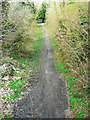
Former M&SWR trackbed, Marlborough
The trackbed is now a cycle route. The line started life as part of the Swindon, Marlborough and Andover (SMAR) railway in the 19th century. The line was subsequently extended to as far north as Cheltenham and was re-named the Midland and South Western Railway. In the grouping of 1923 it was taken over by the Great Western Railway. The line closed to passenger traffic in September 1961. In this view the line is seen as it heads north towards Ogbourne St George. The amateur archaeologist and lover of fast cars Alexander Keiller might once have inadvertently ended up on this section of railway http://www.geograph.org.uk/photo/1224921
Image: © Brian Robert Marshall
Taken: 28 Mar 2009
0.08 miles
5
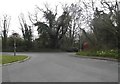
The A4 at the corner of Choppingknife Lane
Image: © David Howard
Taken: 24 Apr 2016
0.08 miles
6
![Once were trains [1]](https://s1.geograph.org.uk/geophotos/05/46/88/5468837_a56bbbfb_120x120.jpg)
Once were trains [1]
Now the Chiseldon and Marlborough Railway Path, this is the trackbed of the former Swindon, Marlborough and Andover Railway later the Midland and South Western Junction Railway, looking south towards Savernake. Services ceased in 1961.
In addition to this through railway, Marlborough was also served by a branch line from the GWR main line at Savernake. The intertwined history of the two lines is well detailed by Wikipedia at: https://en.wikipedia.org/wiki/Marlborough_railway_stations
Image: © Michael Dibb
Taken: 17 Jul 2017
0.08 miles
7
Choppingknife Lane at the junction of the A4
Image: © David Howard
Taken: 24 Apr 2016
0.09 miles
8
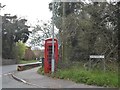
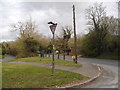
Phone box on the corner of Barnfield, Marlborough
The junction is for Barnfield, Hazel Close and Choppingknife Lane which all branch just beyond this point, but has one name on this side with a different one on the other rather than a list which they usually use in such situations.
Image: © David Howard
Taken: 24 Apr 2016
0.09 miles
10
![Marlborough ways [29]](https://s3.geograph.org.uk/geophotos/05/46/88/5468815_dcfb6ab1_120x120.jpg)
Marlborough ways [29]
From Barnfield the gate leads to the Chiseldon and Marlborough Railway Path which follows the trackbed of the Swindon, Marlborough and Andover Railway later the Midland and South Western Junction Railway. Services ceased in 1961.
In addition to this through railway, Marlborough was also served by a branch line from the GWR main line at Savernake. The intertwined history of the two lines is well detailed by Wikipedia at: https://en.wikipedia.org/wiki/Marlborough_railway_stations
Marlborough is a market town on the Old Bath Road once the main road from London to Bath. The twice-weekly market is sited in High Street, one of the widest in England, lined on both sides with fine listed buildings of which the town has almost 300. There is evidence of local settlement from every period from the prehistoric to the present day. The town is home to the renowned Marlborough College. The River Kennet flows through the town.
Image: © Michael Dibb
Taken: 17 Jul 2017
0.09 miles