IMAGES TAKEN NEAR TO
The Olympia, MARLBOROUGH, SN8 1XF
Introduction
This page details the photographs taken nearby to The Olympia, SN8 1XF by members of the Geograph project.
The Geograph project started in 2005 with the aim of publishing, organising and preserving representative images for every square kilometre of Great Britain, Ireland and the Isle of Man.

There are currently over 7.5m images from over14,400 individuals and you can help contribute to the project by visiting https://www.geograph.org.uk
Image Map (Loading...)


Getting Data...Please wait
Leaflet Map data © OpenStreetMap
Images are licensed for reuse under creativecommons.org/licenses/by-sa/2.0
Notes
- Clicking on the map will re-center to the selected point.
- The higher the marker number, the further away the image location is from the centre of the postcode.
Image Listing (61 Images Found)
Images are licensed for reuse under creativecommons.org/licenses/by-sa/2.0
Image
Details
Distance
1
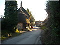
Thatched cottage, Ogbourne St. Andrew
A thatched cottage in the village street.
Image: © Vieve Forward
Taken: 19 Jan 2015
0.03 miles
2
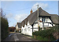
Thatched House, Ogbourne St Andrew
An old house in an ancient village, the name Ogbourne was recorded in the mid 10th century. https://www.british-history.ac.uk/vch/wilts/vol12/pp138-151
The parish includes Rockley and Ogbourne Maizey.
Image: © Des Blenkinsopp
Taken: 11 Feb 2022
0.05 miles
3
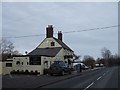
'Silks on the Downs', restaurant and bar, Ogbourne St Andrew
Image: © David Smith
Taken: 27 Dec 2010
0.06 miles
4
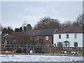
Houses in Ogbourne St Andrew
The main road bypasses some of the older houses of the village, so this village street is at right angles to the through road.
Image: © David Smith
Taken: 27 Dec 2010
0.07 miles
5
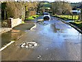
East along the road from Ogbourne St Andrew to the A346
This is almost the southern edge of the village (although there are more houses and a pub on the main road). This stretch of road is often wet as can be seen from the aerial view on Google Earth but lately it has been wetter than ever because of the prolonged wet weather. The high water table in these parts is forcing up water from the manhole in the foreground only for it to drain away via a pot gully a few metres further on.
Image: © Brian Robert Marshall
Taken: 1 Jan 2013
0.08 miles
6
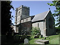
Ogbourne St Andrew, Wiltshire
The church of St Andrew
Image: © ChurchCrawler
Taken: 12 Jul 2003
0.08 miles
7
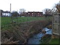
The River Og
The river flows at the end of the car park of the inn Silks on the Downs. In the background are houses in the village of Ogbourne St Andrew
Image: © David Smith
Taken: 30 Dec 2013
0.09 miles
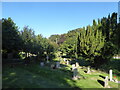
9
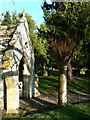
South porch and churchyard, St Andrew's Church, Ogbourne St Andrew, near Marlborough
This is a view east past the flint porch and into the churchyard. The church, which has its origins in the 12th century, is listed Grade I http://www.imagesofengland.org.uk/Details/Default.aspx?id=311315
Image: © Brian Robert Marshall
Taken: 5 Mar 2012
0.09 miles
10
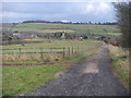
Bridleway heading into Ogbourne St Andrew
From the downs the bridleway heading into Ogbourne St Andrew
Image: © Shaun Ferguson
Taken: 17 Jan 2014
0.09 miles