IMAGES TAKEN NEAR TO
Ogbourne St. Andrew, MARLBOROUGH, SN8 1SB
Introduction
This page details the photographs taken nearby to SN8 1SB by members of the Geograph project.
The Geograph project started in 2005 with the aim of publishing, organising and preserving representative images for every square kilometre of Great Britain, Ireland and the Isle of Man.

There are currently over 7.5m images from over14,400 individuals and you can help contribute to the project by visiting https://www.geograph.org.uk
Image Map
Images are licensed for reuse under creativecommons.org/licenses/by-sa/2.0
Notes
- Clicking on the map will re-center to the selected point.
- The higher the marker number, the further away the image location is from the centre of the postcode.
Image Listing (62 Images Found)
Images are licensed for reuse under creativecommons.org/licenses/by-sa/2.0
Image
Details
Distance
1
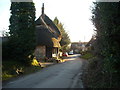
Thatched cottage, Ogbourne St. Andrew
A thatched cottage in the village street.
Image: © Vieve Forward
Taken: 19 Jan 2015
0.02 miles
2
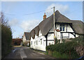
Thatched House, Ogbourne St Andrew
An old house in an ancient village, the name Ogbourne was recorded in the mid 10th century. https://www.british-history.ac.uk/vch/wilts/vol12/pp138-151
The parish includes Rockley and Ogbourne Maizey.
Image: © Des Blenkinsopp
Taken: 11 Feb 2022
0.04 miles
3
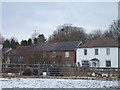
Houses in Ogbourne St Andrew
The main road bypasses some of the older houses of the village, so this village street is at right angles to the through road.
Image: © David Smith
Taken: 27 Dec 2010
0.05 miles
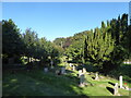
5
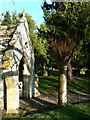
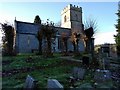
South porch and churchyard, St Andrew's Church, Ogbourne St Andrew, near Marlborough
This is a view east past the flint porch and into the churchyard. The church, which has its origins in the 12th century, is listed Grade I http://www.imagesofengland.org.uk/Details/Default.aspx?id=311315
Image: © Brian Robert Marshall
Taken: 5 Mar 2012
0.06 miles
6
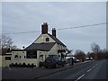
'Silks on the Downs', restaurant and bar, Ogbourne St Andrew
Image: © David Smith
Taken: 27 Dec 2010
0.07 miles
7
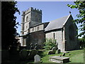
Ogbourne St Andrew, Wiltshire
The church of St Andrew
Image: © ChurchCrawler
Taken: 12 Jul 2003
0.07 miles
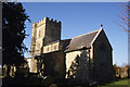
8
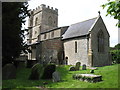
St Andrew's church, Ogbourne St Andrew
The River Og flows south for about 8 kilometres (5 miles) from just south of Swindon until it meets the River Kennet in Marlborough. There were several settlements along this route, and two churches: St George and St Andrew. It is not surprising that the villages surrounding those churches were named after them; in this case, Ogbourne St Andrew.
This church dates originally from the late 12th century with additions from the 13th and 14th centuries. It was restored by William Butterfield in 1847-49. It is Grade I listed by English Heritage: see https://historicengland.org.uk/listing/the-list/list-entry/1033854
Image: © David Purchase
Taken: 25 Jun 2012
0.07 miles
9
Church and grave yard at Ogbourne St Andrew
Image: © Rob Purvis
Taken: 25 Nov 2017
0.07 miles
10
Ogbourne St Andrew - St Andrew's Church
Image: © Colin Park
Taken: 17 Feb 1998
0.08 miles