IMAGES TAKEN NEAR TO
Temple, MARLBOROUGH, SN8 1RU
Introduction
This page details the photographs taken nearby to SN8 1RU by members of the Geograph project.
The Geograph project started in 2005 with the aim of publishing, organising and preserving representative images for every square kilometre of Great Britain, Ireland and the Isle of Man.

There are currently over 7.5m images from over14,400 individuals and you can help contribute to the project by visiting https://www.geograph.org.uk
Image Map (Loading...)


Getting Data...Please wait
Leaflet Map data © OpenStreetMap
Images are licensed for reuse under creativecommons.org/licenses/by-sa/2.0
Notes
- Clicking on the map will re-center to the selected point.
- The higher the marker number, the further away the image location is from the centre of the postcode.
Image Listing (3 Images Found)
Images are licensed for reuse under creativecommons.org/licenses/by-sa/2.0
Image
Details
Distance
1
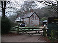
House, Top Temple Farm
Two Temple Farms are marked on the 1:25000 map, one at either end of Temple Bottom. This one is named "Top Temple" on the 1968 map. It would appear that they have been amalgamated into the Temple Farm estate, with a modern mansion, Temple House being built in between. This building may have been the farmhouse to the upper farm, with its redbrick farm cottages and farm yard and barns a little further up the road to the left. The building is made of huge chunks of hard chalk, with brick quoins.
Image: © Vieve Forward
Taken: 12 Dec 2012
0.01 miles
2
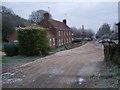
Farm cottages, Temple Farm
Redbrick cottages, probably originally built for farm workers on Temple Farm. There are more farm buildings out of the picture to the right, and a larger house just beyond these cottages.
Image: © Vieve Forward
Taken: 12 Dec 2012
0.05 miles
3
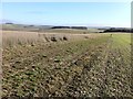
Downland at Temple Farm
The view across the downs here in this part of Wiltshire are tremendous. Difficult to imagine that the ever expanding town of Swindon is only seven miles distant.
Image: © James Harrison
Taken: 18 Jan 2011
0.22 miles