IMAGES TAKEN NEAR TO
Beckhampton, MARLBOROUGH, SN8 1QW
Introduction
This page details the photographs taken nearby to SN8 1QW by members of the Geograph project.
The Geograph project started in 2005 with the aim of publishing, organising and preserving representative images for every square kilometre of Great Britain, Ireland and the Isle of Man.

There are currently over 7.5m images from over14,400 individuals and you can help contribute to the project by visiting https://www.geograph.org.uk
Image Map
Images are licensed for reuse under creativecommons.org/licenses/by-sa/2.0
Notes
- Clicking on the map will re-center to the selected point.
- The higher the marker number, the further away the image location is from the centre of the postcode.
Image Listing (39 Images Found)
Images are licensed for reuse under creativecommons.org/licenses/by-sa/2.0
Image
Details
Distance
1
![A circular walk on the Downs from Avebury [17]](https://s1.geograph.org.uk/geophotos/06/47/07/6470705_1bcb686f_120x120.jpg)
A circular walk on the Downs from Avebury [17]
At the side of the track, a byway, is this marker post for an oil pipeline.
The walk follows footpaths to Beckhampton and then a byway to Allington Down. A short stretch along Wansdyke before a bridleway and later a byway lead back to West Kennet. A footpath, part of the White Horse Trail, runs around Silbury Hill and back to the start. Just over 7½ miles.
Image: © Michael Dibb
Taken: 16 Apr 2020
0.02 miles
2
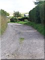
Byway, Beckhampton
The byway heads for Beckhampton Plantation and Allington Down.
Image: © Maigheach-gheal
Taken: 3 Aug 2009
0.04 miles
3
![A circular walk on the Downs from Avebury [22]](https://s1.geograph.org.uk/geophotos/06/47/17/6471753_147c4f53_120x120.jpg)
A circular walk on the Downs from Avebury [22]
A look back along the track, a byway, towards Beckhampton. The white circle to the left of the image is a horse gallop with rails.
The walk follows footpaths to Beckhampton and then a byway to Allington Down. A short stretch along Wansdyke before a bridleway and later a byway lead back to West Kennet. A footpath, part of the White Horse Trail, runs around Silbury Hill and back to the start. Just over 7½ miles.
Image: © Michael Dibb
Taken: 16 Apr 2020
0.06 miles
4
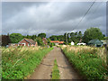
Byway entering Beckhampton
A track from the downs and the Bishops Cannings area enters the western end of the village - a mixture of old and new farm buildings and houses.
Image: © Andrew Smith
Taken: 10 Aug 2008
0.07 miles
5
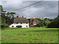
Cottage and house, Beckhampton
Towards the western end of the village which is quiet and bypassed by the nearby main roads.
Image: © Andrew Smith
Taken: 10 Aug 2008
0.07 miles
6
![A circular walk on the Downs from Avebury [15]](https://s0.geograph.org.uk/geophotos/06/47/06/6470696_40e5cc2e_120x120.jpg)
A circular walk on the Downs from Avebury [15]
The byway which leads to Allington Down starts at the village street and is not signposted.
The walk follows footpaths to Beckhampton and then a byway to Allington Down. A short stretch along Wansdyke before a bridleway and later a byway lead back to West Kennet. A footpath, part of the White Horse Trail, runs around Silbury Hill and back to the start. Just over 7½ miles.
Image: © Michael Dibb
Taken: 16 Apr 2020
0.09 miles
7
![A circular walk on the Downs from Avebury [14]](https://s1.geograph.org.uk/geophotos/06/47/06/6470693_427c3973_120x120.jpg)
A circular walk on the Downs from Avebury [14]
Butlers Cottage is 17th century in whitewashed sarsen with a thatched roof. There are some later rear extensions. Another view of the cottage is at Image Listed, grade II, with details at: https://historicengland.org.uk/listing/the-list/list-entry/1365947
The walk follows footpaths to Beckhampton and then a byway to Allington Down. A short stretch along Wansdyke before a bridleway and later a byway lead back to West Kennet. A footpath, part of the White Horse Trail, runs around Silbury Hill and back to the start. Just over 7½ miles.
Image: © Michael Dibb
Taken: 16 Apr 2020
0.11 miles
8
![A circular walk on the Downs from Avebury [13]](https://s0.geograph.org.uk/geophotos/06/47/06/6470692_deca9776_120x120.jpg)
A circular walk on the Downs from Avebury [13]
Butlers Cottage is 17th century in whitewashed sarsen with a thatched roof. There are some later rear extensions. Another view of the cottage is at Image Listed, grade II, with details at: https://historicengland.org.uk/listing/the-list/list-entry/1365947
The walk follows footpaths to Beckhampton and then a byway to Allington Down. A short stretch along Wansdyke before a bridleway and later a byway lead back to West Kennet. A footpath, part of the White Horse Trail, runs around Silbury Hill and back to the start. Just over 7½ miles.
Image: © Michael Dibb
Taken: 16 Apr 2020
0.11 miles
9
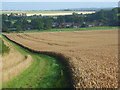
Farmland, Beckhampton
A view over the village and a crop of wheat from the byway to the south
Image: © Andrew Smith
Taken: 10 Aug 2008
0.13 miles
10
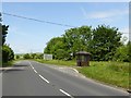
Bus shelter on A361 at Beckhampton
This shelter services the houses reached by the road opposite, which leads to the centre of the village
Image: © David Smith
Taken: 1 Jun 2017
0.16 miles