IMAGES TAKEN NEAR TO
West Kennett, MARLBOROUGH, SN8 1QF
Introduction
This page details the photographs taken nearby to SN8 1QF by members of the Geograph project.
The Geograph project started in 2005 with the aim of publishing, organising and preserving representative images for every square kilometre of Great Britain, Ireland and the Isle of Man.

There are currently over 7.5m images from over14,400 individuals and you can help contribute to the project by visiting https://www.geograph.org.uk
Image Map (Loading...)


Getting Data...Please wait
Leaflet Map data © OpenStreetMap
Images are licensed for reuse under creativecommons.org/licenses/by-sa/2.0
Notes
- Clicking on the map will re-center to the selected point.
- The higher the marker number, the further away the image location is from the centre of the postcode.
Image Listing (63 Images Found)
Images are licensed for reuse under creativecommons.org/licenses/by-sa/2.0
Image
Details
Distance
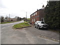
1
![West Kennett houses [4]](https://s2.geograph.org.uk/geophotos/06/56/36/6563666_9839e5c4_120x120.jpg)
West Kennett houses [4]
West Kennett Farmhouse has 17th century origins with an 18th century extension and 19th century alterations. Many 18th and 19th century internal features remain. Listed, grade II, with details at: https://historicengland.org.uk/listing/the-list/list-entry/1035671
The small village of West Kennet sits astride the Old Bath Road, now the A4, which was the Roman road between London and Bath. The village is best known for the West Kennet Long Barrow one of the largest, most impressive and most accessible Neolithic chambered tombs in Britain.
Image: © Michael Dibb
Taken: 15 May 2020
0.01 miles
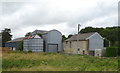
2
![West Kennett buildings [2]](https://s2.geograph.org.uk/geophotos/06/56/36/6563670_f5eb0ef3_120x120.jpg)
West Kennett buildings [2]
This fine cartshed at West Kennet Farm is 18th century although the brick gables and the thatched roof are 20th century. Listed, grade II, with details at: https://historicengland.org.uk/listing/the-list/list-entry/1033753
The small village of West Kennet sits astride the Old Bath Road, now the A4, which was the Roman road between London and Bath. The village is best known for the West Kennet Long Barrow one of the largest, most impressive and most accessible Neolithic chambered tombs in Britain.
Image: © Michael Dibb
Taken: 15 May 2020
0.03 miles

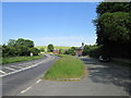
5
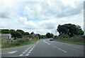
The B4003 junction with the A4 at West Kennett
Image: © Roy Hughes
Taken: 14 Jul 2024
0.04 miles
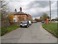
6
![West Kennett buildings [1]](https://s2.geograph.org.uk/geophotos/06/56/36/6563662_d678d621_120x120.jpg)
West Kennett buildings [1]
A disused and abandoned building alongside the A4 road.
The small village of West Kennet sits astride the Old Bath Road, now the A4, which was the Roman road between London and Bath. The village is best known for the West Kennet Long Barrow one of the largest, most impressive and most accessible Neolithic chambered tombs in Britain.
Image: © Michael Dibb
Taken: 15 May 2020
0.05 miles