IMAGES TAKEN NEAR TO
St. Nicholas Yard, MARLBOROUGH, SN8 1PP
Introduction
This page details the photographs taken nearby to St. Nicholas Yard, SN8 1PP by members of the Geograph project.
The Geograph project started in 2005 with the aim of publishing, organising and preserving representative images for every square kilometre of Great Britain, Ireland and the Isle of Man.

There are currently over 7.5m images from over14,400 individuals and you can help contribute to the project by visiting https://www.geograph.org.uk
Image Map (Loading...)


Getting Data...Please wait
Leaflet Map data © OpenStreetMap
Images are licensed for reuse under creativecommons.org/licenses/by-sa/2.0
Notes
- Clicking on the map will re-center to the selected point.
- The higher the marker number, the further away the image location is from the centre of the postcode.
Image Listing (49 Images Found)
Images are licensed for reuse under creativecommons.org/licenses/by-sa/2.0
Image
Details
Distance
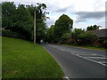
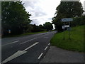
2
![Towards the downs [1]](https://s3.geograph.org.uk/geophotos/06/35/94/6359451_0c1706be_120x120.jpg)
Towards the downs [1]
From the A4 London to Bath road, the public bridleway runs to Fyfield Down and then joins a complex of byways and footpaths on Marlborough Downs.
The village of Fyfield was once closer to the River Kennet. Frequent flooding and a number of cottage fires led in the 1860s to the abandonment of that site in favour of higher ground along the London to Bath road (now the A4). Many of the new cottages, the Fighting Cocks inn and a chapel were demolished when the A4 was widened in the 1930s.
Image: © Michael Dibb
Taken: 2 Sep 2019
0.03 miles
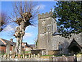
5
Church of St. Nicholas, Fyfield
This modest 13th century parish church built of flint and limestone is separated from the more recent lych gate and graveyard by the village's main thoroughfare.
Image: © Vieve Forward
Taken: 26 Dec 2011
0.04 miles
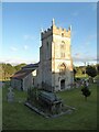
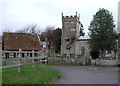
7
![Parish church [1]](https://s1.geograph.org.uk/geophotos/06/35/94/6359465_82da60bf_120x120.jpg)
Parish church [1]
The church of St Nicholas has a 13th century chancel, a 15th century tower and a nave rebuilt in the restoration of 1849. There is a 12th century font but most of the other fittings are 19th century. Listed, grade II*, with details at: https://historicengland.org.uk/listing/the-list/list-entry/1182200
The village of Fyfield was once closer to the River Kennet. Frequent flooding and a number of cottage fires led in the 1860s to the abandonment of that site in favour of higher ground along the London to Bath road (now the A4). Many of the new cottages, the Fighting Cocks inn and a chapel were demolished when the A4 was widened in the 1930s.
Image: © Michael Dibb
Taken: 2 Sep 2019
0.04 miles
8
![Parish church [2]](https://s2.geograph.org.uk/geophotos/06/35/94/6359466_b51be9c7_120x120.jpg)
Parish church [2]
The church of St Nicholas has a 13th century chancel, a 15th century tower and a nave rebuilt in the restoration of 1849. There is a 12th century font but most of the other fittings are 19th century. Listed, grade II*, with details at: https://historicengland.org.uk/listing/the-list/list-entry/1182200
The village of Fyfield was once closer to the River Kennet. Frequent flooding and a number of cottage fires led in the 1860s to the abandonment of that site in favour of higher ground along the London to Bath road (now the A4). Many of the new cottages, the Fighting Cocks inn and a chapel were demolished when the A4 was widened in the 1930s.
Image: © Michael Dibb
Taken: 2 Sep 2019
0.04 miles
9
![Parish church [6]](https://s3.geograph.org.uk/geophotos/06/35/94/6359479_d79209a1_120x120.jpg)
Parish church [6]
The churchyard has a number of chest tombs, some of which are listed.
The church of St Nicholas has a 13th century chancel, a 15th century tower and a nave rebuilt in the restoration of 1849. There is a 12th century font but most of the other fittings are 19th century. Listed, grade II*, with details at: https://historicengland.org.uk/listing/the-list/list-entry/1182200
The village of Fyfield was once closer to the River Kennet. Frequent flooding and a number of cottage fires led in the 1860s to the abandonment of that site in favour of higher ground along the London to Bath road (now the A4). Many of the new cottages, the Fighting Cocks inn and a chapel were demolished when the A4 was widened in the 1930s.
Image: © Michael Dibb
Taken: 2 Sep 2019
0.05 miles
10
![Parish church [5]](https://s0.geograph.org.uk/geophotos/06/35/94/6359472_b4894a77_120x120.jpg)
Parish church [5]
A notice on top of the font.
The church of St Nicholas has a 13th century chancel, a 15th century tower and a nave rebuilt in the restoration of 1849. There is a 12th century font but most of the other fittings are 19th century. Listed, grade II*, with details at: https://historicengland.org.uk/listing/the-list/list-entry/1182200
The village of Fyfield was once closer to the River Kennet. Frequent flooding and a number of cottage fires led in the 1860s to the abandonment of that site in favour of higher ground along the London to Bath road (now the A4). Many of the new cottages, the Fighting Cocks inn and a chapel were demolished when the A4 was widened in the 1930s.
Image: © Michael Dibb
Taken: 2 Sep 2019
0.05 miles