IMAGES TAKEN NEAR TO
Hatford, FARINGDON, SN7 8JG
Introduction
This page details the photographs taken nearby to SN7 8JG by members of the Geograph project.
The Geograph project started in 2005 with the aim of publishing, organising and preserving representative images for every square kilometre of Great Britain, Ireland and the Isle of Man.

There are currently over 7.5m images from over14,400 individuals and you can help contribute to the project by visiting https://www.geograph.org.uk
Image Map
Images are licensed for reuse under creativecommons.org/licenses/by-sa/2.0
Notes
- Clicking on the map will re-center to the selected point.
- The higher the marker number, the further away the image location is from the centre of the postcode.
Image Listing (31 Images Found)
Images are licensed for reuse under creativecommons.org/licenses/by-sa/2.0
Image
Details
Distance
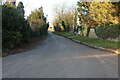
1
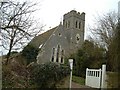
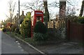
Sandy Lane junction, Hatford
The imposing-looking church in the background has been converted to a dwelling, Church House. If it is listed I've been unable to find details so I suspect it is possibly Victorian. It was sold for conversion in 1972. Hatford is pretty but otherwise unremarkable. It has few amenities having lost its off-licence to a German bomb in 1940. Sandy Lane leads off the main road to the left to join the A420 a few kilometres to the north-west.
Image: © Brian Robert Marshall
Taken: 10 Nov 2010
0.01 miles
2
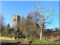
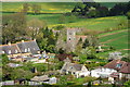
Tower and Tree, Hatford
Hatford's Holy Trinity church was built in 1873 to replace the ancient St George's church which had been the village's place of worship since Saxon times. After serving as the parish church for less than 100 years it was closed in 1972 and converted into a house. Services were moved back to St George's.
Image: © Des Blenkinsopp
Taken: 21 Jan 2020
0.02 miles
3
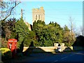
Looking east-northeast along the B4508 at Hatford
Image: © Basher Eyre
Taken: 5 Aug 2020
0.02 miles
4
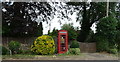
K6 telephone box on the B4508, Hatford
Telephone box now houses a defibrillator.
Image: © JThomas
Taken: 15 Jul 2019
0.02 miles
5
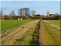
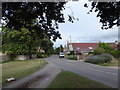
Track and farmland, Hatford
The footpath approaching the village from the south with the former church prominent.
Image: © Andrew Smith
Taken: 14 Jan 2012
0.03 miles
6
The Former Holy Trinity Church, Hatford
Though tiny, Hatford has had two churches. This, the younger, has been deconsecrated and is now a private residence. The older church, St George's, has been reconsecrated. See http://en.wikipedia.org/wiki/Hatford
Image: © Dave Price
Taken: 6 May 2013
0.03 miles
9
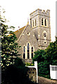
Holy Trinity, Hatford
Built in 1873. Now a private residence.
Image: © Michael FORD
Taken: Unknown
0.03 miles