IMAGES TAKEN NEAR TO
Craven Common, FARINGDON, SN7 7RN
Introduction
This page details the photographs taken nearby to Craven Common, SN7 7RN by members of the Geograph project.
The Geograph project started in 2005 with the aim of publishing, organising and preserving representative images for every square kilometre of Great Britain, Ireland and the Isle of Man.

There are currently over 7.5m images from over14,400 individuals and you can help contribute to the project by visiting https://www.geograph.org.uk
Image Map (Loading...)


Getting Data...Please wait
Leaflet Map data © OpenStreetMap
Images are licensed for reuse under creativecommons.org/licenses/by-sa/2.0
Notes
- Clicking on the map will re-center to the selected point.
- The higher the marker number, the further away the image location is from the centre of the postcode.
Image Listing (11 Images Found)
Images are licensed for reuse under creativecommons.org/licenses/by-sa/2.0
Image
Details
Distance
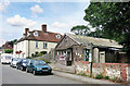
1
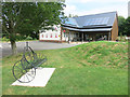
New Store at Uffington
A new Post Office and shop beside the recreation ground. It replaces an old wooden building down the road.
Image: © Des Blenkinsopp
Taken: 5 Aug 2016
0.09 miles
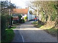
2
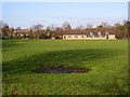
Recreation ground, Uffington
Looking across the park from Upper Common Lane.
Image: © Andrew Smith
Taken: 29 Dec 2007
0.14 miles
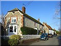
4
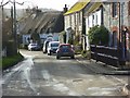
High Street, Uffington
At the junction with Chapel Lane. The cottages are The [former] Baker's Arms and The Old Bakehouse, which are attached, Clock House and Wheelwright (with a thatch wheel on its roof).
Image: © Andrew Smith
Taken: 29 Dec 2007
0.21 miles
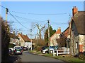
5
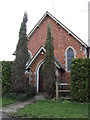
Chapel Lane, Uffington
A small cul-de-sac which gives access to a few cottages, the Baptist chapel and a small post-war estate. On the left is the former Baker's Arms. This hasn't been a pub for some time but the Morland Brewery plaque has been retained and is visible to the extreme left of the picture.
Image: © Andrew Smith
Taken: 29 Dec 2007
0.21 miles
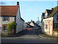
6
Upper Common Lane, Uffington
Looking down to the crossroads formed by the junction with High Street and Chapel Lane. The former Baker's Arms is the building at the junction.
Image: © Andrew Smith
Taken: 29 Dec 2007
0.21 miles
7
High Street, Uffington
Showing Clock House and the Old Bakehouse. The latter is grade II listed and was the bakery until the mid 20th century.
Image: © Andrew Smith
Taken: 29 Dec 2007
0.23 miles
8
High Street, Uffington
High Street is one of the three roads that form a circle around the centre of this lovely village. The cottages show the typical local building materials of chalk ashlar and brick. Many of the cottages are thatched.
Image: © Andrew Smith
Taken: 29 Dec 2007
0.23 miles
9
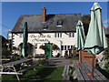
The Fox and Hounds public house in Uffington
Image: © Gareth James
Taken: 26 Sep 2015
0.23 miles
10
Old Store at Uffington
The former Post Office and store has been replaced by a smart new premises just along the road.
Image: © Des Blenkinsopp
Taken: 5 Aug 2016
0.23 miles