IMAGES TAKEN NEAR TO
Uffington, FARINGDON, SN7 7QH
Introduction
This page details the photographs taken nearby to SN7 7QH by members of the Geograph project.
The Geograph project started in 2005 with the aim of publishing, organising and preserving representative images for every square kilometre of Great Britain, Ireland and the Isle of Man.

There are currently over 7.5m images from over14,400 individuals and you can help contribute to the project by visiting https://www.geograph.org.uk
Image Map
Images are licensed for reuse under creativecommons.org/licenses/by-sa/2.0
Notes
- Clicking on the map will re-center to the selected point.
- The higher the marker number, the further away the image location is from the centre of the postcode.
Image Listing (3 Images Found)
Images are licensed for reuse under creativecommons.org/licenses/by-sa/2.0
Image
Details
Distance
2
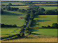
Intersection of Dragon Hill Road and The B4507
The intersection is flanked by farmland on the west north and east of the intersection in this square. The square contains two major farms. The road to the north of the intersection goes to Uffington.
Image: © Pam Brophy
Taken: 9 Jul 2005
0.12 miles
3
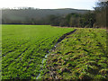
Farmland, Uffington
Beside the footpath north of Britchcombe Farm. The waterlogged nature of the ground can be detected in the foreground. This is just below the line of springs that rise beneath the downland scarp. A brook is in the trees to the right.
Image: © Andrew Smith
Taken: 29 Dec 2007
0.17 miles