IMAGES TAKEN NEAR TO
FARINGDON, SN7 7PJ
Introduction
This page details the photographs taken nearby to SN7 7PJ by members of the Geograph project.
The Geograph project started in 2005 with the aim of publishing, organising and preserving representative images for every square kilometre of Great Britain, Ireland and the Isle of Man.

There are currently over 7.5m images from over14,400 individuals and you can help contribute to the project by visiting https://www.geograph.org.uk
Image Map (Loading...)


Getting Data...Please wait
Leaflet Map data © OpenStreetMap
Images are licensed for reuse under creativecommons.org/licenses/by-sa/2.0
Notes
- Clicking on the map will re-center to the selected point.
- The higher the marker number, the further away the image location is from the centre of the postcode.
Image Listing (4 Images Found)
Images are licensed for reuse under creativecommons.org/licenses/by-sa/2.0
Image
Details
Distance
1
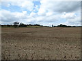
Wicklesham Farm
The public footpath in the picture leads to an extant bridge over the disused Faringdon branch line, the top of which can just be made out in the right of the picture. The line joined the Great Western mainline at Uffington. It was opened in 1864 and the passenger service was withdrawn in 1951. Freight traffic continued until the Beeching cuts in 1964. https://en.wikipedia.org/wiki/Faringdon_branch
Image: © Vieve Forward
Taken: 2 Aug 2019
0.12 miles
2
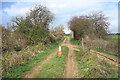
Cone on the Old Railway
Cones get everywhere. This is on the old branch line to Faringdon.
Image: © Des Blenkinsopp
Taken: 6 Apr 2021
0.16 miles
3
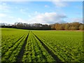
Farmland, Faringdon
Looking towards the course of the former railway from the bridleway to the east of Wickleshamlodge Farm.
Image: © Andrew Smith
Taken: 18 Dec 2011
0.17 miles
4
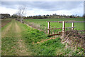
Footbridge, Wickleshamlodge Farm
The path crosses a small ditch.
Image: © Des Blenkinsopp
Taken: 6 Apr 2021
0.24 miles