IMAGES TAKEN NEAR TO
Mudstone Pike, FARINGDON, SN7 7GW
Introduction
This page details the photographs taken nearby to Mudstone Pike, SN7 7GW by members of the Geograph project.
The Geograph project started in 2005 with the aim of publishing, organising and preserving representative images for every square kilometre of Great Britain, Ireland and the Isle of Man.

There are currently over 7.5m images from over14,400 individuals and you can help contribute to the project by visiting https://www.geograph.org.uk
Image Map
Images are licensed for reuse under creativecommons.org/licenses/by-sa/2.0
Notes
- Clicking on the map will re-center to the selected point.
- The higher the marker number, the further away the image location is from the centre of the postcode.
Image Listing (8 Images Found)
Images are licensed for reuse under creativecommons.org/licenses/by-sa/2.0
Image
Details
Distance
1
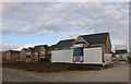
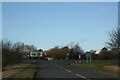
New houses on Fernham Road, Faringdon
From Coxwell Road
Image: © David Howard
Taken: 10 Sep 2019
0.08 miles
2
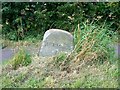
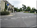
Milestone, south of Faringdon
The milestone is a small one, maybe about 30 centimetres high. The legend is 'Faringdon 1' and is on the left of what was once the main road into Faringdon from the west. It has now been by-passed.
Image: © Brian Robert Marshall
Taken: 23 Jul 2008
0.10 miles
3
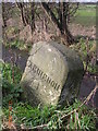
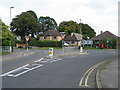
Old Milestone, south of Faringdon
Carved stone post by the UC road (was A420), in parish of Little Coxwell (Vale of White Horse District), Coxwell Road; West of outskirts of Faringdon, 100yds North of Steeds Farm Gate, on grass verge in front of footpath, on West side of road. Faringdon tombstone erected by the Faringdon to Acton Turville (2nd District) turnpike trust in the 19th century.
Inscription reads:-
(F)ARINGDON
1
(S)WINDON
11
Oxfordshire HER.
HER Number: 10122 https://www.heritagegateway.org.uk/Gateway/Results_Single.aspx?uid=MOX10178&resourceID=1033
Milestone Society National ID: BE_FASN01
Image: © A Rosevear
Taken: 16 Sep 2001
0.10 miles
4
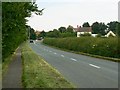
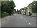
Coxwell Road, south of Faringdon
The south-western outskirts of the Oxfordshire town can be seen in the distance. Not so many years ago this was the main A420 from Oxford to Swindon. It has now been by-passed and mostly local traffic uses the road now.
Image: © Brian Robert Marshall
Taken: 23 Jul 2008
0.11 miles