IMAGES TAKEN NEAR TO
Bourton, SWINDON, SN6 8JH
Introduction
This page details the photographs taken nearby to SN6 8JH by members of the Geograph project.
The Geograph project started in 2005 with the aim of publishing, organising and preserving representative images for every square kilometre of Great Britain, Ireland and the Isle of Man.

There are currently over 7.5m images from over14,400 individuals and you can help contribute to the project by visiting https://www.geograph.org.uk
Image Map
Images are licensed for reuse under creativecommons.org/licenses/by-sa/2.0
Notes
- Clicking on the map will re-center to the selected point.
- The higher the marker number, the further away the image location is from the centre of the postcode.
Image Listing (5 Images Found)
Images are licensed for reuse under creativecommons.org/licenses/by-sa/2.0
Image
Details
Distance
2
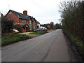
York Cottages, Bourton
Part of a small cluster of houses a short way outside the village.
Image: © Des Blenkinsopp
Taken: 24 Jun 2020
0.04 miles
3
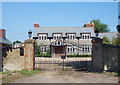
The Grange, Bourton
A large house and other accommodation on three sides of a gated courtyard.
The name is on a stone to the left of the gate.
Image: © Des Blenkinsopp
Taken: 24 Jun 2020
0.14 miles
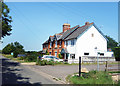
4
Fork at Bourton End
Left to Bourton, right to Shrivenham.
Note the rooks building their nests in the trees above.
Image: © Jonathan Billinger
Taken: 13 Mar 2010
0.17 miles
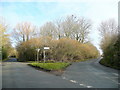
5
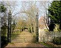
Wrought iron gate
Beyond is Bourton End; viewed from the public road.
Image: © Jonathan Billinger
Taken: 13 Mar 2010
0.19 miles