IMAGES TAKEN NEAR TO
Bourton, SWINDON, SN6 8JE
Introduction
This page details the photographs taken nearby to SN6 8JE by members of the Geograph project.
The Geograph project started in 2005 with the aim of publishing, organising and preserving representative images for every square kilometre of Great Britain, Ireland and the Isle of Man.

There are currently over 7.5m images from over14,400 individuals and you can help contribute to the project by visiting https://www.geograph.org.uk
Image Map
Images are licensed for reuse under creativecommons.org/licenses/by-sa/2.0
Notes
- Clicking on the map will re-center to the selected point.
- The higher the marker number, the further away the image location is from the centre of the postcode.
Image Listing (31 Images Found)
Images are licensed for reuse under creativecommons.org/licenses/by-sa/2.0
Image
Details
Distance
1
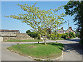
Tree on a traffic island, Lower Bourton
Image: © Des Blenkinsopp
Taken: 24 Jun 2020
0.02 miles
2
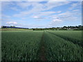
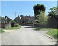
Bridleway from Acorn Bridge to Bourton
The bridleway from Acorn Bridge to Bourton consisted on this occasion of a pair of combine tracks in the wheat. In the distance is the village of Bourton, with Old Manor Farm to the left of Bourton Grange. On the other side of the picture, the Intercity 125 speeds on its way from London to Swindon.
Image: © Vieve Forward
Taken: 9 Jun 2012
0.02 miles
3
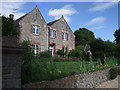
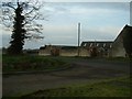
Old Manor Farmhouse, Bourton
Old Manor Farmhouse (not to be confused with the B & B farmhouse of the same name in Little Bourton, near Banbury, Oxfordshire).
Image: © Vieve Forward
Taken: 9 Jun 2012
0.04 miles
5
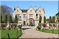
Bourton Grange
Bourton Grange, in the village of Bourton, Oxon.
Image: © Wayland Smith
Taken: 15 Apr 2014
0.06 miles
6
Bourton Grange
Built by John Tucker in 1847, Bourton Grange, with its distinctive Dutch gables, is a grade II listed building. The Tucker family were responsible for the building of much of Bourton in the 1840s and 1850s, including the Church of St. James, the Baptist chapel and six almshouses; they also contributed towards the rebuilding of Pinewood School. http://www.britishlistedbuildings.co.uk/en-250669-bourton-grange-bourton
Image: © Vieve Forward
Taken: 9 Jun 2012
0.06 miles
7
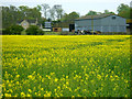
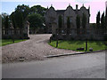
Grange Farm and a field of oilseed rape, Bourton
This is an attempt to find a bit of colour on a grey day. The crop, a member of the brassica family, hasn't quite reached its peak of eye-searing yellowness. Grange Farm, in the background, is on the far side of the London to the west railway hidden in a cutting. The horses visible here were a bonus.
Image: © Brian Robert Marshall
Taken: 29 Apr 2010
0.06 miles
8
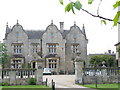
Bourton Grange
Stone-built, gabled manor house on the northern edge of the village of Bourton.
http://www.britishlistedbuildings.co.uk/en-250669-bourton-grange-bourton
Image: © Colin Smith
Taken: 23 May 2008
0.07 miles