IMAGES TAKEN NEAR TO
Skinners Close, SWINDON, SN6 7RR
Introduction
This page details the photographs taken nearby to Skinners Close, SN6 7RR by members of the Geograph project.
The Geograph project started in 2005 with the aim of publishing, organising and preserving representative images for every square kilometre of Great Britain, Ireland and the Isle of Man.

There are currently over 7.5m images from over14,400 individuals and you can help contribute to the project by visiting https://www.geograph.org.uk
Image Map
Images are licensed for reuse under creativecommons.org/licenses/by-sa/2.0
Notes
- Clicking on the map will re-center to the selected point.
- The higher the marker number, the further away the image location is from the centre of the postcode.
Image Listing (33 Images Found)
Images are licensed for reuse under creativecommons.org/licenses/by-sa/2.0
Image
Details
Distance
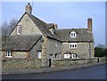
1
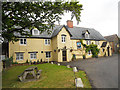
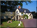
Village houses in Hannington
Hannington has a mixture of traditional stone and brick cottages plus a few 'prefabs' of the 1950's and modern semis and detached dwellings.
Image: © Gordon Hatton
Taken: 3 Jun 2010
0.02 miles
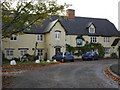
4
The Jolly Tar, Hannington
18th century village pub which is owned by Arkells of Swindon. Good beer, food and guest rooms. The name seems unusual for a place some 40 miles from the nearest tidal water, but apparently it was renamed in the 19th century by a member of the Freke family of Hannington Hall who had nautical connections.
Image: © Gordon Hatton
Taken: 3 Jun 2010
0.06 miles
5
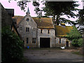
Stable block, Hannington Hall, Queens Road, Hannington
Grade II Listed stone-tiled Cotswold stone stable block at the rear of Hannington Hall, built c.1863. http://www.britishlistedbuildings.co.uk/en-318344-stable-block-at-hannington-hall-hanningt The south block, which can just about be seen to the left of the picture, has three wide coach arches with three dormer windows above. The main block has a central gable with a clock and belfry, and shield panels flanking a central mullioned window. The horseboxes inside the extension to the right are intact.
Image: © Vieve Forward
Taken: 29 Jan 2013
0.06 miles
6
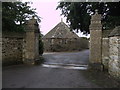
Well house in stable yard, Hannington Hall
Grade II Listed well house in the stable yard of Hannington Hall (see Image]). http://www.britishlistedbuildings.co.uk/en-318345-well-house-in-stable-yard-of-hannington- Built around 1863, this Cotswold stone hexagonal structure with its stone-tiled pyramidal roof formerly housed a donkey wheel for raising water. The street wall and the gatepiers depicted in this picture are also Grade II Listed. http://www.britishlistedbuildings.co.uk/en-318343-street-wall-and-gate-piers-to-south-of-h
Image: © Vieve Forward
Taken: 29 Jan 2013
0.07 miles
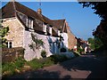
8
Cottages at Hannington
Near the centre of the village.
Image: © Roger Cornfoot
Taken: 5 Feb 2007
0.08 miles
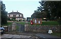
9
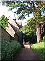
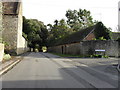
Bridleway into Hannington
To the left of the bridleway is the former stable block of Hannington Hall complete with bellcote.
Image: © Gordon Hatton
Taken: 3 Jun 2010
0.08 miles