IMAGES TAKEN NEAR TO
The Dormers, SWINDON, SN6 7PB
Introduction
This page details the photographs taken nearby to The Dormers, SN6 7PB by members of the Geograph project.
The Geograph project started in 2005 with the aim of publishing, organising and preserving representative images for every square kilometre of Great Britain, Ireland and the Isle of Man.

There are currently over 7.5m images from over14,400 individuals and you can help contribute to the project by visiting https://www.geograph.org.uk
Image Map
Images are licensed for reuse under creativecommons.org/licenses/by-sa/2.0
Notes
- Clicking on the map will re-center to the selected point.
- The higher the marker number, the further away the image location is from the centre of the postcode.
Image Listing (14 Images Found)
Images are licensed for reuse under creativecommons.org/licenses/by-sa/2.0
Image
Details
Distance
1
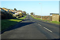
Roundhills Mead, Highworth
Around the east side of the much extended village.
Image: © Robin Webster
Taken: 19 Jan 2020
0.06 miles
2
Arkwrights Whisky, Wines and Home Brew
A small specialist off licence shop.
Image: © Des Blenkinsopp
Taken: 8 Aug 2020
0.12 miles
4
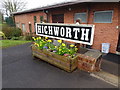
The station sign from the former Highworth railway station
Now located at the Community Centre. See Image for more details.
Image: © Nigel Thompson
Taken: 31 Mar 2018
0.15 miles
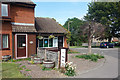
5
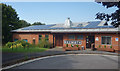
Highworth Community Centre
The town name sign was rescued from the old Highworth station. It can be seen here Image
Image: © Des Blenkinsopp
Taken: 8 Aug 2020
0.16 miles
6
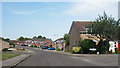
The Cullerns and Priory Green
All addresses in this part of town are either The Cullerns or The Dormers. Except for Priory Green on the right.
Image: © Des Blenkinsopp
Taken: 8 Aug 2020
0.18 miles
7
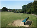
Park next to the Community Centre
A small suburban park on a hillside site.
Image: © Des Blenkinsopp
Taken: 8 Aug 2020
0.18 miles
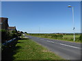
8
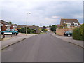
Road leading into The Cullerns
Typical estate road on the new side of Highworth. The Harefield/Cullerns estate (on the east of the hill) started well after the Home Farm council estate and the scottish island road name (Stroma, Islay, Araan, Barra...) Maclean estate which was completed in the early 70s.
Image: © Michael Wright
Taken: 26 May 2007
0.20 miles
9
Roundhills Mead, Highworth
Around the east side of the much extended village.
Image: © Robin Webster
Taken: 19 Jan 2020
0.21 miles
10
![Highworth houses [7]](https://s2.geograph.org.uk/geophotos/06/16/02/6160238_1458a975_120x120.jpg)
Highworth houses [7]
This fine 18th century thatched cottage at 12 Lechlade Road has an ugly modern extension. Listed, grade II, with details at: https://historicengland.org.uk/listing/the-list/list-entry/1355959
Image: © Michael Dibb
Taken: 18 Apr 2019
0.23 miles