IMAGES TAKEN NEAR TO
The Cullerns, SWINDON, SN6 7NR
Introduction
This page details the photographs taken nearby to The Cullerns, SN6 7NR by members of the Geograph project.
The Geograph project started in 2005 with the aim of publishing, organising and preserving representative images for every square kilometre of Great Britain, Ireland and the Isle of Man.

There are currently over 7.5m images from over14,400 individuals and you can help contribute to the project by visiting https://www.geograph.org.uk
Image Map
Images are licensed for reuse under creativecommons.org/licenses/by-sa/2.0
Notes
- Clicking on the map will re-center to the selected point.
- The higher the marker number, the further away the image location is from the centre of the postcode.
Image Listing (215 Images Found)
Images are licensed for reuse under creativecommons.org/licenses/by-sa/2.0
Image
Details
Distance
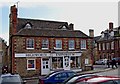
1
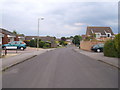
Road leading into The Cullerns
Typical estate road on the new side of Highworth. The Harefield/Cullerns estate (on the east of the hill) started well after the Home Farm council estate and the scottish island road name (Stroma, Islay, Araan, Barra...) Maclean estate which was completed in the early 70s.
Image: © Michael Wright
Taken: 26 May 2007
0.02 miles
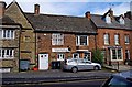
2
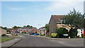
The Cullerns and Priory Green
All addresses in this part of town are either The Cullerns or The Dormers. Except for Priory Green on the right.
Image: © Des Blenkinsopp
Taken: 8 Aug 2020
0.02 miles
3
![Highworth houses [3]](https://s2.geograph.org.uk/geophotos/06/15/90/6159026_4720591e_120x120.jpg)
Highworth houses [3]
The former Parsonage Farmhouse is now part of Parsonage Court housing development. Built circa 1700 and greatly altered circa 1900, this fine building is listed, grade II, with details at: https://historicengland.org.uk/listing/the-list/list-entry/1023343
Image: © Michael Dibb
Taken: 18 Apr 2019
0.10 miles
5
Solicitors office, Sheep Street
Sheep Street is lined with buildings of the eighteenth century, most of which are grade 2 listed. This was once the Red Lion Inn, but is now a solicitors office.
Image: © Gordon Hatton
Taken: 3 Jun 2010
0.11 miles
6
![Highworth buildings [32]](https://s0.geograph.org.uk/geophotos/06/16/02/6160244_92217f41_120x120.jpg)
Highworth buildings [32]
This mid 19th century barn and the adjacent former coach house Image is listed, grade II, with details at: https://historicengland.org.uk/listing/the-list/list-entry/1185027
Image: © Michael Dibb
Taken: 18 Apr 2019
0.11 miles
7
Highworth Emporium (1), 46 High Street, Highworth
This is a family run gift shop, which also has an online internet business. The business has two frontages, one (shown here) is onto Market Place, and the other, around the corner, is onto High Street.
Image
Image: © P L Chadwick
Taken: 11 Mar 2011
0.11 miles
8
Highworth Emporium (2), 46 High Street, Highworth
The main entrance to this gift shop is around the corner in Market Place. The building the Highworth Emporium occupies, or part of it, was long ago in the early 17th century, an inn called the "Holy Lamb Inn". Later it was renamed the "King's Head". After ceasing to be an inn, it was for many years a grocer's shop.
Image
Image: © P L Chadwick
Taken: 11 Mar 2011
0.11 miles
9
Highworth Post Office
Situated on Sheep Street which overlooks the Market Place from the north.
Image: © Gordon Hatton
Taken: 3 Jun 2010
0.11 miles
10
![Highworth houses [17]](https://s3.geograph.org.uk/geophotos/06/16/02/6160243_8e19badd_120x120.jpg)
Highworth houses [17]
This early 19th century former coach house is now known as Nauvoo Cottage. The cottage and the adjacent barn Image are listed, grade II, with details at: https://historicengland.org.uk/listing/the-list/list-entry/1185027
Image: © Michael Dibb
Taken: 18 Apr 2019
0.12 miles