IMAGES TAKEN NEAR TO
North View, SWINDON, SN6 7EJ
Introduction
This page details the photographs taken nearby to North View, SN6 7EJ by members of the Geograph project.
The Geograph project started in 2005 with the aim of publishing, organising and preserving representative images for every square kilometre of Great Britain, Ireland and the Isle of Man.

There are currently over 7.5m images from over14,400 individuals and you can help contribute to the project by visiting https://www.geograph.org.uk
Image Map
Images are licensed for reuse under creativecommons.org/licenses/by-sa/2.0
Notes
- Clicking on the map will re-center to the selected point.
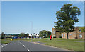
- The higher the marker number, the further away the image location is from the centre of the postcode.
Image Listing (143 Images Found)
Images are licensed for reuse under creativecommons.org/licenses/by-sa/2.0
Image
Details
Distance
1
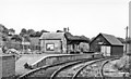
Highworth station, 1950
View eastward to the buffer-stops of the terminus of the ex-GWR branch from Swindon (Highworth Junction), closed to passengers 2/3/53, to goods 6/8/62. (See also my Image).
Image: © Walter Dendy, deceased
Taken: 24 Sep 1950
0.01 miles
2
Highworth railway station (site), Wiltshire
Opened in 1883 by the Great Western Railway as the terminus of a branch line from Swindon, this station closed to passengers in 1953 and completely in 1962.
View south west towards Hannington and Swindon, from a similar viewpoint to Image The road known as Windrush appears to follow the track of the former railway at this point. No trace of the former station appears to remain here but the station sign does - see Image
Image: © Nigel Thompson
Taken: 31 Mar 2018
0.07 miles
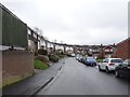
3
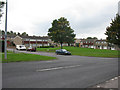
Housing estates
The Hampton Hill part of Highworth, developed in the 1960's and 70's.
Image: © Jonathan Billinger
Taken: 4 Jan 2007
0.11 miles
4
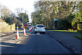
Road works on Cricklade Road, Highworth
The B4019.
Image: © Robin Webster
Taken: 19 Jan 2020
0.11 miles
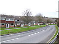
5
St Michael's Avenue, Highworth
The main neighbourhood road, it loops round connecting all the residential no through roads which make up this area.
Image: © Des Blenkinsopp
Taken: 8 Aug 2020
0.12 miles
6
![Highworth houses [26]](https://s2.geograph.org.uk/geophotos/06/16/53/6165350_64fa19cc_120x120.jpg)
Highworth houses [26]
Number 24 Cricklade Road is circa 1818 and is listed, grade II, with details at: https://historicengland.org.uk/listing/the-list/list-entry/1023340
Image: © Michael Dibb
Taken: 18 Apr 2019
0.13 miles
7
![Highworth houses [31]](https://s3.geograph.org.uk/geophotos/06/16/53/6165347_d95f7e45_120x120.jpg)
Highworth houses [31]
Westrop House was built in 1878 for the Lord of the Manor. Many original fine internal features remain. Listed, grade II, with details at: https://historicengland.org.uk/listing/the-list/list-entry/1184675
Image: © Michael Dibb
Taken: 18 Apr 2019
0.14 miles
8
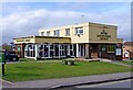
The Goldfinger Tavern
Estate pub in Highworth.
Image: © Jonathan Billinger
Taken: 4 Jan 2007
0.14 miles
9
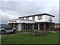
Goldfinger Tavern, Newburgh Place, Highworth
A typical estate pub of the 1960's, with a flat roof. It is surrounded by the Home Farm and Windrush estates, in the west of Highworth. It has had a chequered history, with at times a rapid turnover of managers. For some years it has been owned by the Greene King brewery of Sudbury, Suffolk, which hopefully has brought some stability. It recently underwent a makeover.
Image: © P L Chadwick
Taken: 11 Mar 2011
0.16 miles
10
Northern end of Windrush from St Michael's Avenue
Image: © Nick Smith
Taken: 24 Sep 2011
0.16 miles