IMAGES TAKEN NEAR TO
Orange Close, SWINDON, SN6 7BD
Introduction
This page details the photographs taken nearby to Orange Close, SN6 7BD by members of the Geograph project.
The Geograph project started in 2005 with the aim of publishing, organising and preserving representative images for every square kilometre of Great Britain, Ireland and the Isle of Man.

There are currently over 7.5m images from over14,400 individuals and you can help contribute to the project by visiting https://www.geograph.org.uk
Image Map
Images are licensed for reuse under creativecommons.org/licenses/by-sa/2.0
Notes
- Clicking on the map will re-center to the selected point.
- The higher the marker number, the further away the image location is from the centre of the postcode.
Image Listing (223 Images Found)
Images are licensed for reuse under creativecommons.org/licenses/by-sa/2.0
Image
Details
Distance
1
![Highworth buildings [31]](https://s1.geograph.org.uk/geophotos/06/16/02/6160241_35868ef7_120x120.jpg)
Highworth buildings [31]
This delightful garden pavilion is in the rear garden wall of number 9 Sheep Street. Listed, grade II, with details at: https://historicengland.org.uk/listing/the-list/list-entry/1299850
Image: © Michael Dibb
Taken: 18 Apr 2019
0.09 miles
2
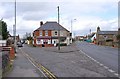
Junction of Westrop and Lechlade Road, Highworth
The road on the left is Westrop, that on the right is Lechlade Road. Many years ago, I seem to recollect that the houses in the middle included at least one shop.
Image: © P L Chadwick
Taken: 11 Mar 2011
0.09 miles
3
![Highworth buildings [32]](https://s0.geograph.org.uk/geophotos/06/16/02/6160244_92217f41_120x120.jpg)
Highworth buildings [32]
This mid 19th century barn and the adjacent former coach house Image is listed, grade II, with details at: https://historicengland.org.uk/listing/the-list/list-entry/1185027
Image: © Michael Dibb
Taken: 18 Apr 2019
0.09 miles
4
The Cullerns and Priory Green
All addresses in this part of town are either The Cullerns or The Dormers. Except for Priory Green on the right.
Image: © Des Blenkinsopp
Taken: 8 Aug 2020
0.09 miles
5
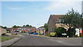
Road leading into The Cullerns
Typical estate road on the new side of Highworth. The Harefield/Cullerns estate (on the east of the hill) started well after the Home Farm council estate and the scottish island road name (Stroma, Islay, Araan, Barra...) Maclean estate which was completed in the early 70s.
Image: © Michael Wright
Taken: 26 May 2007
0.09 miles
6
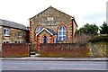
Highworth Silver Band, The Band Hall, Lechlade Road, Highworth
The band is a brass band and has been in existence since at least 1887, when a local newspaper reported that it had performed for Queen Victoria's Golden Jubilee celebrations. These days it is not a contesting band. It acquired this building in 1964. Previously it had been a Wesleyan (Methodist) chapel. The dedication stone at the top of the building reads "Wesleyan Chapel 1842". Prior to acquiring the building, the band used to rehearse in the Fishes public house (now closed) and the Saracens Head Hotel.
Image: © P L Chadwick
Taken: 11 Mar 2011
0.09 miles
7
![Highworth buildings [30]](https://s0.geograph.org.uk/geophotos/06/16/02/6160220_e7a38b31_120x120.jpg)
Highworth buildings [30]
Since 1964 this redundant Wesleyan chapel has been home to the Highworth Silver Band. The chapel was erected circa 1850.
Image: © Michael Dibb
Taken: 18 Apr 2019
0.09 miles
8
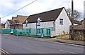
The former White Horse Inn (1), Lechlade Road, Highworth
When photographed in March 2011, this pub was well under way in being converted to a private house. It used to be a popular pub, with live music and for many years was the home of the White Horse Folk Club, who have moved elsewhere. However, it obviously wasn't popular enough because by late 2009, or earlier, it had closed. It joins a long list of pub closures in Highworth, with at least two in the last few years. To the left can be seen new houses, being constructed on the pub's former car park. By the time this photograph was taken, all the pub's signage had been removed.
Image
Image: © P L Chadwick
Taken: 11 Mar 2011
0.09 miles
9
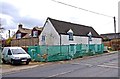
The former White Horse Inn (2), Lechlade Road, Highworth
In the process of being converted into a private residence. See:- Image
Image: © P L Chadwick
Taken: 11 Mar 2011
0.09 miles
10
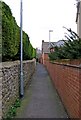
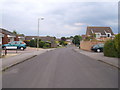
Footpath from Lechlade Road to Cherry Orchard, Highworth
Looking in the direction of Cherry Orchard, which is a residential street.
Image: © P L Chadwick
Taken: 11 Mar 2011
0.10 miles