IMAGES TAKEN NEAR TO
Portwell, SWINDON, SN6 6SA
Introduction
This page details the photographs taken nearby to Portwell, SN6 6SA by members of the Geograph project.
The Geograph project started in 2005 with the aim of publishing, organising and preserving representative images for every square kilometre of Great Britain, Ireland and the Isle of Man.

There are currently over 7.5m images from over14,400 individuals and you can help contribute to the project by visiting https://www.geograph.org.uk
Image Map (Loading...)


Getting Data...Please wait
Leaflet Map data © OpenStreetMap
Images are licensed for reuse under creativecommons.org/licenses/by-sa/2.0
Notes
- Clicking on the map will re-center to the selected point.
- The higher the marker number, the further away the image location is from the centre of the postcode.
Image Listing (308 Images Found)
Images are licensed for reuse under creativecommons.org/licenses/by-sa/2.0
Image
Details
Distance
1
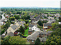
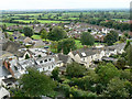
View south from St Sampson's tower, Cricklade
The view shows mostly fairly recent housing south of the church. The road at the left is the B4553 road to Purton.
Image: © Brian Robert Marshall
Taken: 6 Sep 2009
0.02 miles
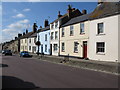
3
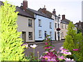
Georgian Cottages, Cricklade
Old houses in the old town's main street - now painted in attractive pastel shades.
Image: © Colin Smith
Taken: 16 Jul 2009
0.03 miles
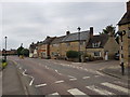
4
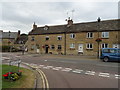
High Street
High Street in Crickalde.
Image: © Wayland Smith
Taken: 25 May 2020
0.03 miles
5
View south-east from St Sampson's tower, Cricklade
At the far left-centre is Cricklade Town Hall, on the east side of the B4040. At the extreme left horizon it is possible to distinguish the trees on Liddington Hill over 17 kilometres away seen closer to here http://www.geograph.org.uk/photo/434234
Image: © Brian Robert Marshall
Taken: 6 Sep 2009
0.04 miles
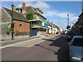
6
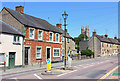
South end of High Street, Cricklade, Wiltshire
Image: © Jeff Gogarty
Taken: 9 Aug 2020
0.04 miles
8
Terraced houses on Cricklade's main street
Image: © Nick Smith
Taken: 27 Sep 2009
0.05 miles
9
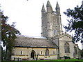
Cricklade: St. Sampson's Church
The massive tower of the parish church with its four tall rounded turrets dominates Cricklade and is a landmark for miles around. There has been a stone church here since the foundation of the borough in about 890. Dedicated to St. Sampson, who founded the Abbey-Bishopric of Dol in Brittany, it is one of only five named after him. Most of the present church was built between 1240 and 1280 but some traces of much earlier work remain. A major restoration took place in 1864. The tower is reputed to have been built by the Duke of Northumberland, father-in-law of Lady Jane Grey, between 1551 and 1553.
Image: © Nigel Cox
Taken: 24 Oct 2006
0.06 miles
10
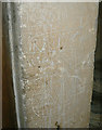
Graffiti, St Sampson's Church, Cricklade
There are numerous examples of ancient graffiti, mostly 17th and 18th century, in the church tower. This one is of a three-masted ship.
Image: © Brian Robert Marshall
Taken: 6 Sep 2009
0.06 miles