IMAGES TAKEN NEAR TO
Common Hill, SWINDON, SN6 6EZ
Introduction
This page details the photographs taken nearby to Common Hill, SN6 6EZ by members of the Geograph project.
The Geograph project started in 2005 with the aim of publishing, organising and preserving representative images for every square kilometre of Great Britain, Ireland and the Isle of Man.

There are currently over 7.5m images from over14,400 individuals and you can help contribute to the project by visiting https://www.geograph.org.uk
Image Map
Images are licensed for reuse under creativecommons.org/licenses/by-sa/2.0
Notes
- Clicking on the map will re-center to the selected point.
- The higher the marker number, the further away the image location is from the centre of the postcode.
Image Listing (4 Images Found)
Images are licensed for reuse under creativecommons.org/licenses/by-sa/2.0
Image
Details
Distance
2
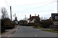
Common Hill roundabout, Cricklade
Common Hill is about half a mile to the west (right). It rises less than 30m. In this rather flat country near the Cotswold Water Park, it doesn't take much to be classed as a hill.
Image: © David Purchase
Taken: 1 Nov 2016
0.12 miles
3
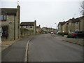
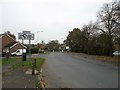
Reeds, Cricklade
Reeds is the rather unusual street name for this housing development on the north-west of Cricklade.
Image: © David Purchase
Taken: 1 Nov 2016
0.16 miles
4
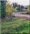
Old Milestone, Common Hill, Cricklade
On the SE verge of the B4040 by the farm gate. First erected by the Faringdon to Acton Turville Turnpike Trust.
Inscription (was) Cricklade 1 / Malmesbury 11
Milestone Society National ID: WI_MYCK11
Image: © Tom Blanden
Taken: 29 Nov 2022
0.17 miles