IMAGES TAKEN NEAR TO
Rectory Lane, SWINDON, SN6 6DB
Introduction
This page details the photographs taken nearby to Rectory Lane, SN6 6DB by members of the Geograph project.
The Geograph project started in 2005 with the aim of publishing, organising and preserving representative images for every square kilometre of Great Britain, Ireland and the Isle of Man.

There are currently over 7.5m images from over14,400 individuals and you can help contribute to the project by visiting https://www.geograph.org.uk
Image Map
Images are licensed for reuse under creativecommons.org/licenses/by-sa/2.0
Notes
- Clicking on the map will re-center to the selected point.
- The higher the marker number, the further away the image location is from the centre of the postcode.
Image Listing (298 Images Found)
Images are licensed for reuse under creativecommons.org/licenses/by-sa/2.0
Image
Details
Distance
1
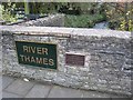
Bridge over the Thames
A reminder on the bridge in Cricklade.
Image: © David Stowell
Taken: 5 Nov 2008
0.01 miles
2
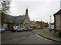
Cricklade
Looking towards the town centre from the bridge over the River Thames
Image: © David Stowell
Taken: 5 Nov 2008
0.01 miles
3
![Cricklade houses [25]](https://s0.geograph.org.uk/geophotos/06/34/64/6346436_2e44254c_120x120.jpg)
Cricklade houses [25]
This view takes in numbers 1A (nearest the camera), 1, 2 and 3 Rectory Lane. The row is probably a 19th century conversion of the rear outbuildings of number 61 High Street. Numbers 1 and 2 are listed, grade II, with details at: https://historicengland.org.uk/listing/the-list/list-entry/1284150
Cricklade is the first town downstream on the River Thames. The town was founded by the Anglo-Saxons in the 9th century at the point where the Roman Ermin Way crosses the River Thames. It is one of the thirty burhs (fortified towns) recorded in the Burghal Hidage document, which describes a system of fortresses and fortified towns built around Wessex by King Alfred. The fortifications have been extensively excavated in several places on all four of its sides.
Image: © Michael Dibb
Taken: 25 Aug 2019
0.01 miles
4
![Cricklade houses [20]](https://s1.geograph.org.uk/geophotos/06/34/56/6345649_28d027ea_120x120.jpg)
Cricklade houses [20]
Number 68 High Street is 17th or 18th century and has an orthostatic wall joining the facade to the north. Listed, grade II, with details at: https://historicengland.org.uk/listing/the-list/list-entry/1023112
Cricklade is the first town downstream on the River Thames. The town was founded by the Anglo-Saxons in the 9th century at the point where the Roman Ermin Way crosses the River Thames. It is one of the thirty burhs (fortified towns) recorded in the Burghal Hidage document, which describes a system of fortresses and fortified towns built around Wessex by King Alfred. The fortifications have been extensively excavated in several places on all four of its sides.
Image: © Michael Dibb
Taken: 25 Aug 2019
0.02 miles
5
![Cricklade houses [17]](https://s3.geograph.org.uk/geophotos/06/34/56/6345643_5944fac1_120x120.jpg)
Cricklade houses [17]
Number 65 High Street is 17th or 18th century with a continuous timber lintel. Listed, grade II, with details at: https://historicengland.org.uk/listing/the-list/list-entry/1183191
Cricklade is the first town downstream on the River Thames. The town was founded by the Anglo-Saxons in the 9th century at the point where the Roman Ermin Way crosses the River Thames. It is one of the thirty burhs (fortified towns) recorded in the Burghal Hidage document, which describes a system of fortresses and fortified towns built around Wessex by King Alfred. The fortifications have been extensively excavated in several places on all four of its sides.
Image: © Michael Dibb
Taken: 25 Aug 2019
0.02 miles
6
![Cricklade houses [15]](https://s3.geograph.org.uk/geophotos/06/34/56/6345635_7b8f347e_120x120.jpg)
Cricklade houses [15]
The third bay of this late 18th or early 19th century house at number 63 High Street has a lower roof line. Listed, grade II, with details at: https://historicengland.org.uk/listing/the-list/list-entry/1023110
Cricklade is the first town downstream on the River Thames. The town was founded by the Anglo-Saxons in the 9th century at the point where the Roman Ermin Way crosses the River Thames. It is one of the thirty burhs (fortified towns) recorded in the Burghal Hidage document, which describes a system of fortresses and fortified towns built around Wessex by King Alfred. The fortifications have been extensively excavated in several places on all four of its sides.
Image: © Michael Dibb
Taken: 25 Aug 2019
0.02 miles
7
![Cricklade houses [16]](https://s2.geograph.org.uk/geophotos/06/34/56/6345642_f4d71efb_120x120.jpg)
Cricklade houses [16]
Number 64 High Street, The Old Stores, is 17th or 18th century and has a blocked opening to the right. Listed, grade II, with details at: https://historicengland.org.uk/listing/the-list/list-entry/1023111
Cricklade is the first town downstream on the River Thames. The town was founded by the Anglo-Saxons in the 9th century at the point where the Roman Ermin Way crosses the River Thames. It is one of the thirty burhs (fortified towns) recorded in the Burghal Hidage document, which describes a system of fortresses and fortified towns built around Wessex by King Alfred. The fortifications have been extensively excavated in several places on all four of its sides.
Image: © Michael Dibb
Taken: 25 Aug 2019
0.02 miles
8
![Cricklade houses [18]](https://s0.geograph.org.uk/geophotos/06/34/56/6345644_7e3ebcbf_120x120.jpg)
Cricklade houses [18]
Number 66 High Street is 17th or 18th century with a continuous timber lintel. Listed, grade II, with detyails at: https://historicengland.org.uk/listing/the-list/list-entry/1356065
Cricklade is the first town downstream on the River Thames. The town was founded by the Anglo-Saxons in the 9th century at the point where the Roman Ermin Way crosses the River Thames. It is one of the thirty burhs (fortified towns) recorded in the Burghal Hidage document, which describes a system of fortresses and fortified towns built around Wessex by King Alfred. The fortifications have been extensively excavated in several places on all four of its sides.
Image: © Michael Dibb
Taken: 25 Aug 2019
0.03 miles
9
![Cricklade houses [19]](https://s1.geograph.org.uk/geophotos/06/34/56/6345645_b2327f4a_120x120.jpg)
Cricklade houses [19]
Number 67 High Street, Little Cottage, is 17th or 18th century and is listed for group value, grade II, with details at: https://historicengland.org.uk/listing/the-list/list-entry/1183194
Cricklade is the first town downstream on the River Thames. The town was founded by the Anglo-Saxons in the 9th century at the point where the Roman Ermin Way crosses the River Thames. It is one of the thirty burhs (fortified towns) recorded in the Burghal Hidage document, which describes a system of fortresses and fortified towns built around Wessex by King Alfred. The fortifications have been extensively excavated in several places on all four of its sides.
Image: © Michael Dibb
Taken: 25 Aug 2019
0.03 miles
10
North Wall, Cricklade
The street name gives away the route of the old Saxon walls which surrounded the town. There are still low earthen traces of the Saxon town walls in some places here.
http://www.cricklade-tc.gov.uk/
Image: © Colin Smith
Taken: 16 Jul 2009
0.03 miles