IMAGES TAKEN NEAR TO
SN5 9BT
Introduction
This page details the photographs taken nearby to SN5 9BT by members of the Geograph project.
The Geograph project started in 2005 with the aim of publishing, organising and preserving representative images for every square kilometre of Great Britain, Ireland and the Isle of Man.

There are currently over 7.5m images from over14,400 individuals and you can help contribute to the project by visiting https://www.geograph.org.uk
Image Map
Images are licensed for reuse under creativecommons.org/licenses/by-sa/2.0
Notes
- Clicking on the map will re-center to the selected point.
- The higher the marker number, the further away the image location is from the centre of the postcode.
Image Listing (6 Images Found)
Images are licensed for reuse under creativecommons.org/licenses/by-sa/2.0
Image
Details
Distance
1
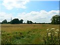
Footpath from Battlewell, Purton
The footpath leads away from the viewpoint towards the south-west. The high-voltage power lines are just inside this square.
Image: © Brian Robert Marshall
Taken: 22 Jul 2008
0.08 miles
2
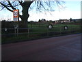
Roadside pond, near Dogridge, Purton
This pond, decorated with old wheels, is fed by marshy land above it, and runs via Purton Mill to join the River Ray.
Image: © Vieve Forward
Taken: 25 Dec 2013
0.10 miles
3
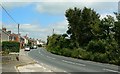
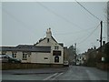
Restrop Road, Purton
In this view Restrop Road is seen as it leads to the village of Purton. Travel in the other direction and you will pass through Greatfield and Hook before crossing the M4 on the way to Wootton Bassett.
Image: © Brian Robert Marshall
Taken: 22 Jul 2008
0.10 miles
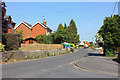
6
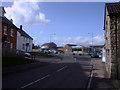
Mini-roundabout and shops, Purton
A busy group of shops stands near this mini-roundabout at the junction of High Street, Restrop Road and Pavenhill.
Image: © Vieve Forward
Taken: 3 Mar 2012
0.25 miles