IMAGES TAKEN NEAR TO
Lambert Close, SWINDON, SN5 8NY
Introduction
This page details the photographs taken nearby to Lambert Close, SN5 8NY by members of the Geograph project.
The Geograph project started in 2005 with the aim of publishing, organising and preserving representative images for every square kilometre of Great Britain, Ireland and the Isle of Man.

There are currently over 7.5m images from over14,400 individuals and you can help contribute to the project by visiting https://www.geograph.org.uk
Image Map
Images are licensed for reuse under creativecommons.org/licenses/by-sa/2.0
Notes
- Clicking on the map will re-center to the selected point.
- The higher the marker number, the further away the image location is from the centre of the postcode.
Image Listing (13 Images Found)
Images are licensed for reuse under creativecommons.org/licenses/by-sa/2.0
Image
Details
Distance
1
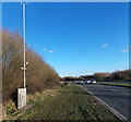
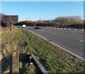
Roadside weather monitoring equipment, Swindon
Among the sensors on a pole alongside the A3102 Great Western Way are an anemometer (for measuring wind speed) and a vane (for showing wind direction). Lower down is an air temperature sensor.
Image: © Jaggery
Taken: 2 Feb 2013
0.10 miles
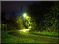
3
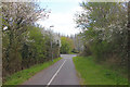
Swindon cyclepath
Cyclepath in Swindon leading towards Frankland Road.
Image: © Wayland Smith
Taken: 4 Apr 2020
0.13 miles
4
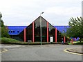
Water Research Centre, Frankland Road, Swindon
The building was constructed in the 1980s as the home for the Water Research Centre who, in a similar way to British Homes Stores becoming bhs, are now the WRc. The building sits on the gridline between this and SU1182 but everything visible here is in this square.
Image: © Brian Robert Marshall
Taken: 20 Aug 2007
0.14 miles
5
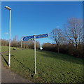
Signpost in Toothill Park, Swindon
One arm points uphill towards Toothill village centre and West Swindon district centre.
The other arm points in the direction of Windmill Hill business park.
Image: © Jaggery
Taken: 2 Feb 2013
0.14 miles
6
Garbled electronic display alongside the A3102 Great Western Way, Swindon
The sign is near the southern edge of Toothill Park.
Image: © Jaggery
Taken: 2 Feb 2013
0.15 miles
7
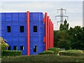
Water Research Centre, Frankland Road, Swindon
The WRc (as it now is) building sits on the gridline between this square and the next one north. This view is parallel with the northern gridline of this square. Everything to the right of the red component on the front elevation is in this square as is the viewpoint.
Image: © Brian Robert Marshall
Taken: 20 Aug 2007
0.16 miles
8
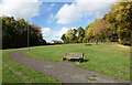
Toothill Park
A bit of suburban parkland on the southern slope of Toot Hill.
Image: © Des Blenkinsopp
Taken: 17 Oct 2022
0.16 miles
9
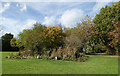
Small Pond on Toot Hill
In Toothill Park near the top of the hill is a small and very overgrown pond.
Image: © Des Blenkinsopp
Taken: 17 Oct 2022
0.20 miles
10
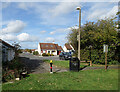
Alnwick from Toothill Park
Coming out of Toothill Park at the north entrance and looking along a road which according to the map is simply called Alnwick.
Image: © Des Blenkinsopp
Taken: 17 Oct 2022
0.21 miles