1
Bus stop and shelter on Whitehill Way, Swindon
Image: © JThomas
Taken: 14 Jul 2019
0.07 miles
2
Whitehill Way, Swindon
Approaching a roundabout on the B4534.
Image: © JThomas
Taken: 14 Jul 2019
0.14 miles
3
De Vere Hotel, Swindon
Image: © Philip Halling
Taken: 24 Jun 2009
0.15 miles
4
Pizza Hut, Swindon
On Whitehill Way.
Image: © JThomas
Taken: 14 Jul 2019
0.15 miles
5
Part of the De Vere village hotel complex, Swindon
The entrance drive to the 'village' complex which comprises a De Vere hotel linked to a cinema and ten pin bowling alley and associated car parking spaces. The hotel houses an Italian themed restaurant and a (very expensive) pub. De Vere were until recently called 'The Alternative Hotels Group' but hey, what's in a name? Nice rooms, great staff, good conference facilities and all you might hope for in a hotel.
Image: © Jeremy Bolwell
Taken: 6 Nov 2012
0.16 miles
6
De Vere Hotel, Shaw Ridge Leisure Park, West Swindon
Shaw Ridge is a leisure park including an hotel, pictured here, restaurant, ten-pin bowling and a multiplex cinema.
Image: © Brian Robert Marshall
Taken: 9 Apr 2008
0.17 miles
7
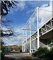
Masts at the Link Centre
Interesting architecture at the Link Sports Centre. A touch of the Tall Ships in that design.
Image: © Des Blenkinsopp
Taken: 17 Oct 2022
0.17 miles
8
Castle Dore, Swindon
Another of the many residential no through roads which make up this area.
Image: © Des Blenkinsopp
Taken: 17 Oct 2022
0.18 miles
9
Part of the Link Centre, Swindon
As Swindon expanded rapidly in the 1970's and 1980's this was the sort of building that the town wanted; a big architectural statement, no doubt nominated and maybe even winning design awards and plaudits but it has, I understand, been plagued with some of the issues that Councils dread - Legionella in the water supply system, floods, electrical failures related to floods and an on-going maintenance and building expenses bill far beyond what anyone envisaged when beaming at architects plans in halcyon days long ago.
Plus, to a visitor at least, it isn't immediately obvious where the entrance door is. I virtually circumnavigated it before finding it.
It's a leisure centre (housing 'the biggest indoor climbing-wall in Wiltshire'), ice rink (home to Swindon Wildcats ice hockey team), library (scarlet carpet tiles!) and community centre.
Yes, it does look like a waste incinerating facility, dockside warehouse or a bus depot maybe.
Image: © Jeremy Bolwell
Taken: 6 Nov 2012
0.19 miles
10
Roundabout on Whitehill Way, Swindon
Image: © David Howard
Taken: 26 Oct 2019
0.20 miles


