1
Brookhouse Farm by Middleaze Drive
Brookhouse Farm is a Hungry Horse public house.
Image: © Steve Daniels
Taken: 13 Mar 2023
0.11 miles
2
Old Other Stone by Tewkesbury Way, Lydiard Millicent
Commemorative Marker by the UC road, in parish of Lydiard Millicent (North Wiltshire District), Tewkesbury Way, just East of roundabout, back of verge.
Inscription reads:-
LYDIARD
MILLICENT
PARISH 2000
D W REVERE
Surveyed
Milestone Society National ID: WI_LYDM03cm
Image: © Milestone Society
Taken: Unknown
0.12 miles
3
Silage field, Middleleaze, Swindon
Image: © JThomas
Taken: 14 Jul 2019
0.13 miles
4
Brook House Farm
Once an isolated farmhouse, in the 1980's, this building was converted into a pub-restaurant, during the rapid western expansion of Swindon. It is now part of the 'Hungry Horse' chain.
Image: © Roger Cornfoot
Taken: 10 Jan 2007
0.13 miles
5
Entering Lydiard Millicent
On a minor road from Swindon.
Image: © JThomas
Taken: 14 Jul 2019
0.14 miles
6
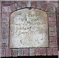
Old Boundary Marker by Tewkesbury Way, Lydiard Millicent
Parish Boundary Marker by the UC road, in parish of Lydiard Millicent (North Wiltshire District), Tewkesbury Way, just East of roundabout, re-sited above cycle way underpass.
Out of place - in public view
Inscription reads:-
Thus far of
this Road
towards Marlbro
belong's to
Liddiard Millicent
Milestone Society National ID: WI_LYDM04pb
Image: © Milestone Society
Taken: Unknown
0.14 miles
7
Swindon Skyline
Although the immediate vicinity feels very rural, you can make out the Swindon skyline to the east.
Image: © Martin Elliott
Taken: 28 Apr 2011
0.14 miles
8
Footpath towards Tewkesbury Way
Once a main route into Swindon from Lydiard Millicent, it was bypassed in the early 1990's and has since been requiring a great need of attention.
Image: © Robert Gourley
Taken: 19 Jun 2013
0.16 miles
9
Lydiard Tregoze Park
Image: © Michael Garlick
Taken: 19 May 2017
0.20 miles
10
Footpath from Lydiard Millicent to Lydiard Tregoze
There are three Lydiards: Green, Millicent and Tregoze. Lydiard Millicent is the largest. The footpath can be made out leading away from the viewpoint in between the buttercups.
Image: © Brian Robert Marshall
Taken: 11 May 2008
0.20 miles


