IMAGES TAKEN NEAR TO
Portmore Close, SWINDON, SN5 5FB
Introduction
This page details the photographs taken nearby to Portmore Close, SN5 5FB by members of the Geograph project.
The Geograph project started in 2005 with the aim of publishing, organising and preserving representative images for every square kilometre of Great Britain, Ireland and the Isle of Man.

There are currently over 7.5m images from over14,400 individuals and you can help contribute to the project by visiting https://www.geograph.org.uk
Image Map
Images are licensed for reuse under creativecommons.org/licenses/by-sa/2.0
Notes
- Clicking on the map will re-center to the selected point.
- The higher the marker number, the further away the image location is from the centre of the postcode.
Image Listing (17 Images Found)
Images are licensed for reuse under creativecommons.org/licenses/by-sa/2.0
Image
Details
Distance
1
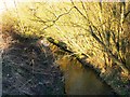
Stream near Sparcells, Swindon
The stream flows into the River Ray a few hundred metres north of here. The River Ray Image is one of two tributaries of the Thames that flow through Swindon. The other is the River Cole Image
Image: © Brian Robert Marshall
Taken: 11 Feb 2010
0.03 miles
2
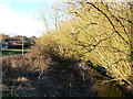
River Ray feeder and Sparcells, Swindon
The stream seen here feeds into the small tributary of the Thames which flows through the western part of Swindon. The housing at the left is part of the Sparcells development built in the 1980s.
Image: © Brian Robert Marshall
Taken: 11 Feb 2010
0.03 miles
3
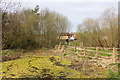
Near Spacells
Small lake by the cyclepath on the edge of Shaw Forest Park.
Image: © Wayland Smith
Taken: 5 Apr 2020
0.05 miles
4
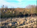
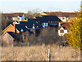
Sparcells from Shaw Forest Park, Swindon
The 1980s housing estate lies in two grid-squares, this one and SU1186 to the left or west. The viewpoint is just inside the subject square looking very slightly west of north. Thus the right-hand part of the image showing the houses is in SU1286 as is most of the foreground.
Image: © Brian Robert Marshall
Taken: 11 Feb 2010
0.08 miles
5
A bridge over a tributary of the River Ray
Image: © Steve Daniels
Taken: 2 Sep 2009
0.08 miles
6
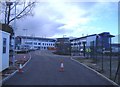
New school on Akers Way
A large school complex is being constructed next to Hreod Parkway comprehensive.
Image: © Roger Cornfoot
Taken: 10 Jan 2007
0.15 miles
7
Part of Sparcells, Swindon
Sparcells is a pleasant private residential development constructed in the 1980s. The viewpoint is from the Shaw Forest Park.
Image: © Brian Robert Marshall
Taken: 11 Feb 2010
0.18 miles
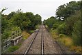
9
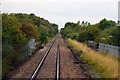
Bridge over the old Swindon & Cricklade Railway
Image: © Steve Daniels
Taken: 2 Sep 2009
0.19 miles
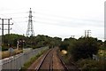
10
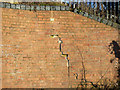
Abutment, railway bridge, near Haydon Wick, Swindon
This is part of the bridge seen here Image There has been some movement over the years and the brickwork is showing signs of that. Two tell-tales can be seen installed across the crack one of which can be seen here Image
Image: © Brian Robert Marshall
Taken: 11 Feb 2010
0.19 miles