IMAGES TAKEN NEAR TO
High Street, SWINDON, SN5 4BB
Introduction
This page details the photographs taken nearby to High Street, SN5 4BB by members of the Geograph project.
The Geograph project started in 2005 with the aim of publishing, organising and preserving representative images for every square kilometre of Great Britain, Ireland and the Isle of Man.

There are currently over 7.5m images from over14,400 individuals and you can help contribute to the project by visiting https://www.geograph.org.uk
Image Map
Images are licensed for reuse under creativecommons.org/licenses/by-sa/2.0
Notes
- Clicking on the map will re-center to the selected point.
- The higher the marker number, the further away the image location is from the centre of the postcode.
Image Listing (10 Images Found)
Images are licensed for reuse under creativecommons.org/licenses/by-sa/2.0
Image
Details
Distance
1
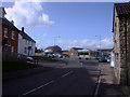
Mini-roundabout and shops, Purton
A busy group of shops stands near this mini-roundabout at the junction of High Street, Restrop Road and Pavenhill.
Image: © Vieve Forward
Taken: 3 Mar 2012
0.08 miles
4
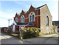
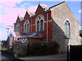
Former chapel, Hoggs Lane, Purton
The former Primitive Methodist chapel is now a house.
Image: © Robin Webster
Taken: 25 Mar 2017
0.10 miles
5
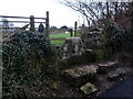
Stile, Hoggs Lane, Purton
Stone stile, Hoggs Lane, looking towards the western end of the High Street.
Image: © Vieve Forward
Taken: 3 Mar 2012
0.15 miles
6
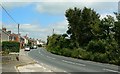
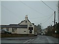
Restrop Road, Purton
In this view Restrop Road is seen as it leads to the village of Purton. Travel in the other direction and you will pass through Greatfield and Hook before crossing the M4 on the way to Wootton Bassett.
Image: © Brian Robert Marshall
Taken: 22 Jul 2008
0.17 miles
7
![Purton houses [11]](https://s1.geograph.org.uk/geophotos/06/35/68/6356825_50363f06_120x120.jpg)
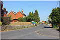
Purton houses [11]
The Close, number 26 High Street, is an 18th century farmhouse now a private house. Listed, grade II, with details at: https://historicengland.org.uk/listing/the-list/list-entry/1356023
Originally built round the parish church, manor and Tithe barn, the village moved and is now mostly spread out along the Bristol and Oxford coach road.
Image: © Michael Dibb
Taken: 28 Aug 2019
0.21 miles
9
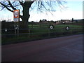
Roadside pond, near Dogridge, Purton
This pond, decorated with old wheels, is fed by marshy land above it, and runs via Purton Mill to join the River Ray.
Image: © Vieve Forward
Taken: 25 Dec 2013
0.24 miles
10
![Purton houses [10]](https://s3.geograph.org.uk/geophotos/06/35/68/6356823_39387a68_120x120.jpg)
Purton houses [10]
A glimpse of Hallidays, number 24 High Street, behind its Leylandii hedge. The house is dated 1794 with 19th century alterations. Listed, grade II, with details at: https://historicengland.org.uk/listing/the-list/list-entry/1198388
Originally built round the parish church, manor and Tithe barn, the village moved and is now mostly spread out along the Bristol and Oxford coach road.
Image: © Michael Dibb
Taken: 28 Aug 2019
0.24 miles