IMAGES TAKEN NEAR TO
Holborn, SWINDON, SN5 3ND
Introduction
This page details the photographs taken nearby to Holborn, SN5 3ND by members of the Geograph project.
The Geograph project started in 2005 with the aim of publishing, organising and preserving representative images for every square kilometre of Great Britain, Ireland and the Isle of Man.

There are currently over 7.5m images from over14,400 individuals and you can help contribute to the project by visiting https://www.geograph.org.uk
Image Map
Images are licensed for reuse under creativecommons.org/licenses/by-sa/2.0
Notes
- Clicking on the map will re-center to the selected point.
- The higher the marker number, the further away the image location is from the centre of the postcode.
Image Listing (6 Images Found)
Images are licensed for reuse under creativecommons.org/licenses/by-sa/2.0
Image
Details
Distance
1
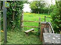
Footpath entrance, Lydiard Millicent
The footpath leads away from the stile to the south-east. At the right is a private garden.
Image: © Brian Robert Marshall
Taken: 11 May 2008
0.02 miles
2
Holborn, Lydiard Millicent
Hamlet east of Lydiard Millicent.
Image: © Vieve Forward
Taken: 30 Dec 2012
0.03 miles
3
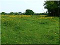
Footpath from Lydiard Millicent to Lydiard Tregoze
There are three Lydiards: Green, Millicent and Tregoze. Lydiard Millicent is the largest. The footpath can be made out leading away from the viewpoint in between the buttercups.
Image: © Brian Robert Marshall
Taken: 11 May 2008
0.09 miles
4
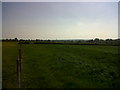
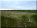
Swindon Skyline
Although the immediate vicinity feels very rural, you can make out the Swindon skyline to the east.
Image: © Martin Elliott
Taken: 28 Apr 2011
0.11 miles
5
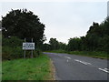
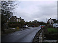
Entering Lydiard Millicent
On a minor road from Swindon.
Image: © JThomas
Taken: 14 Jul 2019
0.11 miles