IMAGES TAKEN NEAR TO
Winterbourne Bassett, SWINDON, SN4 9QE
Introduction
This page details the photographs taken nearby to SN4 9QE by members of the Geograph project.
The Geograph project started in 2005 with the aim of publishing, organising and preserving representative images for every square kilometre of Great Britain, Ireland and the Isle of Man.

There are currently over 7.5m images from over14,400 individuals and you can help contribute to the project by visiting https://www.geograph.org.uk
Image Map
Images are licensed for reuse under creativecommons.org/licenses/by-sa/2.0
Notes
- Clicking on the map will re-center to the selected point.
- The higher the marker number, the further away the image location is from the centre of the postcode.
Image Listing (7 Images Found)
Images are licensed for reuse under creativecommons.org/licenses/by-sa/2.0
Image
Details
Distance
1
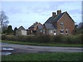
Cottages at Whyr farm
An isolated farm community, at the end of a long, no-through-road, west of Winterbourne Bassett.
Image: © Roger Cornfoot
Taken: 5 Mar 2007
0.01 miles
2
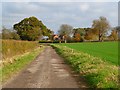
Farmland and byway, Winterbourne Bassett
The approach to cottages at Whyr Farm from the west.
Image: © Andrew Smith
Taken: 6 Nov 2011
0.03 miles
3
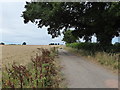
Byway near Whyr Farm
Though it is a byway open to all traffic, one would expect to see farm vehicles here rather than a yellow 2CV.
Image: © Vieve Forward
Taken: 22 Jul 2018
0.13 miles
4

The road to Whyr Farm, near Winterbourne Bassett
The road terminates a little over 200 metres away from the viewpoint. When you reach the end there are two footpaths and a byway to choose from if you want to go any further.
Image: © Brian Robert Marshall
Taken: 21 Oct 2008
0.15 miles
5

Oak tree on the road from Whyr Farm, Winterbourne Bassett
I'm no good at assessing the age of trees but by oak standards this is probably quite young, perhaps a few decades old.
Image: © Brian Robert Marshall
Taken: 21 Oct 2008
0.19 miles
6

Farmland under attack, west of Winterbourne Bassett
A mix of rooks and gulls are working the field for food. The northern gridline of the square is about 170 metres ahead of the viewpoint meaning that the rooks are in the square, although it's unlikely they know that. The trees beyond are out of the square.
Image: © Brian Robert Marshall
Taken: 21 Oct 2008
0.20 miles
7

The road from Whyr Farm, near Winterbourne Bassett
The road serves the farm and its associated cottages and not much else.
Image: © Brian Robert Marshall
Taken: 21 Oct 2008
0.21 miles