IMAGES TAKEN NEAR TO
Broad Hinton, SWINDON, SN4 9PH
Introduction
This page details the photographs taken nearby to SN4 9PH by members of the Geograph project.
The Geograph project started in 2005 with the aim of publishing, organising and preserving representative images for every square kilometre of Great Britain, Ireland and the Isle of Man.

There are currently over 7.5m images from over14,400 individuals and you can help contribute to the project by visiting https://www.geograph.org.uk
Image Map
Images are licensed for reuse under creativecommons.org/licenses/by-sa/2.0
Notes
- Clicking on the map will re-center to the selected point.
- The higher the marker number, the further away the image location is from the centre of the postcode.
Image Listing (32 Images Found)
Images are licensed for reuse under creativecommons.org/licenses/by-sa/2.0
Image
Details
Distance
1
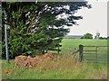
Path leaves the road
The public footpath runs towards Manor Farm where it joins another path which runs to Snow Hill.
Image: © Michael Dibb
Taken: 24 Jul 2019
0.01 miles
2
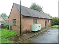
Broad Hinton Telephone Exchange
Situated north west of Broad Hinton, this redbrick building would appear to date from the GPO era ie before 1969, and has the code SSBHN. It provides telephone and broadband services to 640 residential and 48 non-residential premises in Broad Hinton, Berwick Bassett, Broad Town, Bushton, Clyffe Pypard, Uffcott, Winterbourne Bassett and the surrounding rural area. Two pale green generators can be seen by the side of the TE. Its numbering range is (01793) 731xxx, the (01793) referring to the Swindon group of fourteen TEs, and its postcode is SN4 9PH.
Image: © David Hillas
Taken: 16 Aug 2019
0.01 miles
3
![Broad Hinton buildings [5]](https://s0.geograph.org.uk/geophotos/06/27/29/6272920_2308adec_120x120.jpg)
Broad Hinton buildings [5]
The small building amongst the trees is a telephone exchange. See also Image
Broad Hinton is a small village off the road from Avebury to Wroughton over Marlborough Downs.
Image: © Michael Dibb
Taken: 24 Jul 2019
0.02 miles
4
![Broad Hinton buildings [6]](https://s1.geograph.org.uk/geophotos/06/27/29/6272921_a8473c8e_120x120.jpg)
Broad Hinton buildings [6]
On the gate of the drive leading to the telephone exchange Image are these warning signs.
Broad Hinton is a small village off the road from Avebury to Wroughton over Marlborough Downs.
Image: © Michael Dibb
Taken: 24 Jul 2019
0.03 miles
5
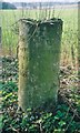
Old Milestone by Broad Town Road, Broad Hinton
Swindon thin 'D' stone by the UC road (was B4041), in parish of Broad Hinton (Kennet District), Broad Town Road, just beyond North West edge of village, 400m North of Manor Farm, in nettles on open verge in front of wire fence.
Inscription reads:-
: TO / WOOTTON / BASSETT / 4 / MILES : : TO / MARLBRO / 8 / MILES :
Grade II listed.
List Entry Number: 1182056 https://historicengland.org.uk/listing/the-list/list-entry/1182056
Surveyed
Milestone Society National ID: WI_mlwb08
Image: © Milestone Society
Taken: Unknown
0.07 miles
6
![Broad Hinton buildings [4]](https://s2.geograph.org.uk/geophotos/06/27/29/6272914_615333f3_120x120.jpg)
Broad Hinton buildings [4]
Just visible through the trees at Manor Farm are these outbuildings. Amongst them is a 17th or early 18th century granary.
Broad Hinton is a small village off the road from Avebury to Wroughton over Marlborough Downs.
Image: © Michael Dibb
Taken: 24 Jul 2019
0.09 miles
7
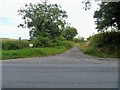
Byway leaves the road
The track, Vize Lane, is a byway and runs from Broad Hinton to Lambourne Ground.
Image: © Michael Dibb
Taken: 24 Jul 2019
0.09 miles
8
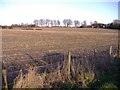
Maize stubble
A large arable field, to the west of Broad Hinton.
Image: © Roger Cornfoot
Taken: 21 Jan 2007
0.12 miles
9
![Broad Hinton houses [9]](https://s1.geograph.org.uk/geophotos/06/27/29/6272913_a3db84d3_120x120.jpg)
Broad Hinton houses [9]
Manor Farmhouse is Late 17th century with an 18th century rear wing. The Roman Doric portico is early 19th century. The farmhouse is probably on the site of Hinton Vase Manor. Listed, grade II, with details at: https://historicengland.org.uk/listing/the-list/list-entry/1033875
Broad Hinton is a small village off the road from Avebury to Wroughton over Marlborough Downs.
Image: © Michael Dibb
Taken: 24 Jul 2019
0.13 miles
10
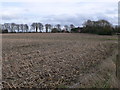
Field of maize stubble
Looking east towards Broad Hinton.
Image: © Eirian Evans
Taken: 16 Feb 2011
0.13 miles