
IMAGES TAKEN NEAR TO
Winterbourne Monkton, SWINDON, SN4 9NW
Introduction
This page details the photographs taken nearby to SN4 9NW by members of the Geograph project.
The Geograph project started in 2005 with the aim of publishing, organising and preserving representative images for every square kilometre of Great Britain, Ireland and the Isle of Man.

There are currently over 7.5m images from over14,400 individuals and you can help contribute to the project by visiting https://www.geograph.org.uk
Image Map
Images are licensed for reuse under creativecommons.org/licenses/by-sa/2.0
Notes
- Clicking on the map will re-center to the selected point.
- The higher the marker number, the further away the image location is from the centre of the postcode.
Image Listing (56 Images Found)
Images are licensed for reuse under creativecommons.org/licenses/by-sa/2.0
Image
Details
Distance
1
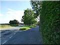
Swindon Road, Winterbourne Monkton
To the right is the old road alignment; it has now been straightened.
Image: © Stephen Craven
Taken: 15 Jul 2022
0.04 miles
2

Bus stop on Swindon Road, Winterbourne Monkton
With passengers about to board a bus to Devizes.
Image: © Stephen Craven
Taken: 15 Jul 2022
0.04 miles
3

Bus stop, Winterbourne Monkton
The blue bus stop is about 11 metres from the northern gridline of the square.
Image: © Brian Robert Marshall
Taken: 15 Jul 2008
0.04 miles
4

Standing stones, Winterbourne Monkton
Hidden away by trees, the stones are much smaller than their world-famous counterparts to be found at Avebury a few kilometres to the south. How they came to be here remains a mystery to me at least.
Image: © Brian Robert Marshall
Taken: 15 Jul 2008
0.05 miles
5

Hay bales, Winterbourne Monkton
In a field alongside the main road through the village.
Image: © Stephen Craven
Taken: 15 Jul 2022
0.06 miles
6

The house with no name?
This thatched cottage in Winterbourne Monkton is listed grade II (list entry 1182998) but it is intriguingly titled 'No name for this Entry'. The largest scale on MagicMap doesn't even give a number or name for it either. Note the detail of a highwayman on the end of the thatched ridge, a change from the more usual animal figure. With that clue, I did find a reference to 'Highwaymans Cottage, 211 Winterbourne Monkton'.
Image: © Stephen Craven
Taken: 15 Jul 2022
0.07 miles
7

Footbridge over the River Kennet
When this was taken the river bed was completely dry.
Image: © Guy Wareham
Taken: 18 Sep 2010
0.08 miles
8

The Kennet at Winterbourne Monkton
The same view as this one from 4 years ago Image A bit more water this year, but not that much considering how wet it's been.
Image: © Des Blenkinsopp
Taken: 26 Feb 2014
0.10 miles
9

The upper Kennet at Winterbourne Monkton 1
The river above Avebury bifurcates into two headwaters; this being the northern tributary, looking north, upstream.
Image: © Jonathan Billinger
Taken: 18 Feb 2010
0.12 miles
10

View north from Church Lane
Looking over the upper Kennet valley pastures.
Image: © Jonathan Billinger
Taken: 18 Feb 2010
0.12 miles