IMAGES TAKEN NEAR TO
Savill Crescent, SWINDON, SN4 9JG
Introduction
This page details the photographs taken nearby to Savill Crescent, SN4 9JG by members of the Geograph project.
The Geograph project started in 2005 with the aim of publishing, organising and preserving representative images for every square kilometre of Great Britain, Ireland and the Isle of Man.

There are currently over 7.5m images from over14,400 individuals and you can help contribute to the project by visiting https://www.geograph.org.uk
Image Map
Images are licensed for reuse under creativecommons.org/licenses/by-sa/2.0
Notes
- Clicking on the map will re-center to the selected point.
- The higher the marker number, the further away the image location is from the centre of the postcode.
Image Listing (18 Images Found)
Images are licensed for reuse under creativecommons.org/licenses/by-sa/2.0
Image
Details
Distance
2
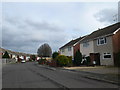
Bungalows, Wharf Road, Wroughton
Many neat little bungalows line this side of Wharf Road, with a hedge and footpath to separate them from the traffic.
Image: © Vieve Forward
Taken: 2 Jan 2013
0.07 miles
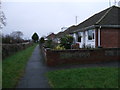
3
![Path leaves the road [1]](https://s1.geograph.org.uk/geophotos/05/78/91/5789149_9cb8d746_120x120.jpg)
Path leaves the road [1]
Starting at Wharf Road, the footpath leads to Elcombe.
Image: © Michael Dibb
Taken: 19 May 2018
0.07 miles
4
![Path leaves the road [2]](https://s0.geograph.org.uk/geophotos/05/78/91/5789152_29fc474a_120x120.jpg)
Path leaves the road [2]
Starting at Wharf Road, the footpath leads to Basset Down.
Image: © Michael Dibb
Taken: 19 May 2018
0.07 miles
5
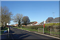
Bus Stops on Wharf Road
The wharf in this case would have been on the Wilts & Berks Canal which was a short way north of here. Wharf Farm is still there too, but the canal closed over 100 years ago.
Having said that, some of it nearby has been restored recently as part of the Wychelstowe development, so you never know.
Image: © Des Blenkinsopp
Taken: 19 Jan 2023
0.09 miles
6
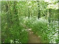
Ashen Copse
A path runs through this small piece of woodland in Wharf Road.
Image: © Michael Dibb
Taken: 19 May 2018
0.11 miles
7
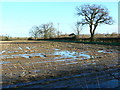
Farmland, Wharf Road, Wroughton
The field shows the effects of the recent wet weather. Visible behind the hedge and tree to the right are the northernmost houses of Wroughton itself.
Image: © Brian Robert Marshall
Taken: 20 Jan 2007
0.12 miles
8
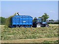
Gathering the grass
The field has been mown and the grass raked into rows and allowed to wilt before being collected. Usually stacked in a pit and covered, the grass will turn into silage and will be used to feed the stock in the colder months. Seen from the footpath.
Image: © Michael Dibb
Taken: 19 May 2018
0.15 miles
9
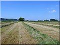
Awaiting collection
The field has been mown and the grass raked into rows awaiting collection. Usually stacked in a pit and covered, the grass will turn into silage and will be used to feed the stock in the colder months. Seen from the footpath.
Image: © Michael Dibb
Taken: 19 May 2018
0.15 miles
10
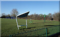
Park Scene, Wroughton
A small park off Maunsell Way on the northern edge of Wroughton.
Image: © Des Blenkinsopp
Taken: 19 Jan 2023
0.15 miles