IMAGES TAKEN NEAR TO
Nore Marsh Road, SWINDON, SN4 8BH
Introduction
This page details the photographs taken nearby to Nore Marsh Road, SN4 8BH by members of the Geograph project.
The Geograph project started in 2005 with the aim of publishing, organising and preserving representative images for every square kilometre of Great Britain, Ireland and the Isle of Man.

There are currently over 7.5m images from over14,400 individuals and you can help contribute to the project by visiting https://www.geograph.org.uk
Image Map
Images are licensed for reuse under creativecommons.org/licenses/by-sa/2.0
Notes
- Clicking on the map will re-center to the selected point.
- The higher the marker number, the further away the image location is from the centre of the postcode.
Image Listing (21 Images Found)
Images are licensed for reuse under creativecommons.org/licenses/by-sa/2.0
Image
Details
Distance
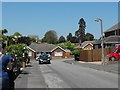
1
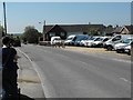
Nore Marsh Road, Wootton Bassett
Van sales yard on the right. Opposite it is all residential housing.
Image: © Penny Mayes
Taken: 22 May 2012
0.03 miles
2
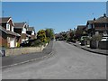
Parsons Way, Wootton Bassett
Viewed from Washbourne Road. Both roads were developed for housing in the 1960s. The nearby Noremarsh Junior School was built around the same time.
Image: © Penny Mayes
Taken: 22 May 2012
0.05 miles
3
Washbourne Road, Royal Wootton Bassett
Viewed from Nore Marsh Road.
Image: © Jaggery
Taken: 2 Feb 2013
0.13 miles
4
Noremarsh Junior School, Royal Wootton Bassett
A view of the school's south side. The school's entrance is on its NE side, from Clarendon Drive.
Image: © Jaggery
Taken: 2 Feb 2013
0.13 miles
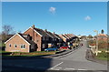
5
Washbourne Road, Wootton Bassett
Part of a fairly extensive housing development built in the 1960s. The nearby Noremarsh Junior School was built around the same time.
Clarendon Drive is the road at the end and beyond that, on the right, is the town cemetery.
Image: © Penny Mayes
Taken: 22 May 2012
0.14 miles
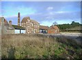
6

Derelict buildings, Station Road, Wootton Bassett
This was once the Beaufort Brewery then it became a transport depot. Now it is apparently unused. It is listed Grade II http://www.imagesofengland.org.uk/details/default.aspx?id=316847
Image: © Brian Robert Marshall
Taken: 17 Mar 2009
0.18 miles
7
Old brewery, Wootton Bassett
These buildings are all that remain today of the former St Ivel factory complex, on this site.
Image: © Roger Cornfoot
Taken: 2 Jan 2007
0.18 miles
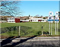
8
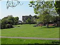
Small park adjacent to Noremarsh Junior School
The large building in the background is the Council Offices http://www.geograph.org.uk/photo/2973102 .
Image: © Penny Mayes
Taken: 22 May 2012
0.19 miles
9
Former Beaufort Brewery building, Station Road, Royal Wootton Bassett
Grade II former brewery building of Beaufort Brewery, later part of St.Ivel creamery, now derelict. Situated on the edge of a new estate.http://www.britishlistedbuildings.co.uk/en-316847-wincanton-transport-depot-wootton-basset http://www.imagesofengland.org.uk/details/default.aspx?id=316847 http://www.flickr.com/photos/swindonlocal/6008895732/
Image: © Vieve Forward
Taken: 8 Oct 2013
0.19 miles
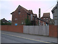
10
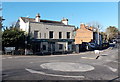
Fenced-off derelict former Town Local Pub, Royal Wootton Bassett
The location is the corner of Station Road and Nore Marsh Road.
This view http://www.geograph.org.uk/photo/103327 taken 7 years earlier shows the pub when it was open.
Image: © Jaggery
Taken: 2 Feb 2013
0.19 miles