IMAGES TAKEN NEAR TO
Ruxley Close, SWINDON, SN4 7LB
Introduction
This page details the photographs taken nearby to Ruxley Close, SN4 7LB by members of the Geograph project.
The Geograph project started in 2005 with the aim of publishing, organising and preserving representative images for every square kilometre of Great Britain, Ireland and the Isle of Man.

There are currently over 7.5m images from over14,400 individuals and you can help contribute to the project by visiting https://www.geograph.org.uk
Image Map
Images are licensed for reuse under creativecommons.org/licenses/by-sa/2.0
Notes
- Clicking on the map will re-center to the selected point.
- The higher the marker number, the further away the image location is from the centre of the postcode.
Image Listing (74 Images Found)
Images are licensed for reuse under creativecommons.org/licenses/by-sa/2.0
Image
Details
Distance
1
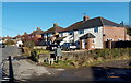
Morstone Road houses, Royal Wootton Bassett
Houses on the east side of Morstone Road, viewed from the corner of New Road.
Image: © Jaggery
Taken: 2 Feb 2013
0.07 miles
2
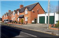
New Road houses, Royal Wootton Bassett
Houses on the north side of New Road, west of Pipers Close. http://www.geograph.org.uk/photo/3319772
Image: © Jaggery
Taken: 2 Feb 2013
0.09 miles
3
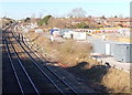
Eastern edge of Westbury Park, Royal Wootton Bassett
Viewed from the New Road end. Westbury Park is a large cul-de-sac
with about 90 houses located on the north side of railway lines.
Image: © Jaggery
Taken: 2 Feb 2013
0.10 miles
4

An as yet unrenamed bus shelter, Royal Wootton Bassett
The honour bestowed upon Wootton Bassett by Queen Elizabeth II in 2011 was a grant of royal patronage in recognition of the town's role in early 21st century military funeral repatriations. Many names on display in the town now show Royal Wootton Bassett. Some do not yet. One example in this New Road bus shelter located opposite the Morstone Road junction.
Image: © Jaggery
Taken: 2 Feb 2013
0.12 miles
5
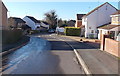
Pipers Close, Royal Wootton Bassett
This is the western end of a short cul-de-sac located between New Road and railway lines.
Image: © Jaggery
Taken: 2 Feb 2013
0.13 miles
6
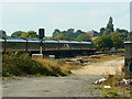
Eastern edge of Wootton Bassett junction, Royal Wootton Bassett
View from a footbridge http://www.geograph.org.uk/photo/3319868 looking towards Skew Bridge. This is the junction of the line from Bristol via Bath and Chippenham on the left and the line from South Wales via Bristol Parkway on the right.
Image: © Jaggery
Taken: 2 Feb 2013
0.14 miles
7
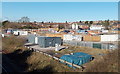
New Road building site, Royal Wootton Bassett
Viewed from this footbridge. http://www.geograph.org.uk/photo/3319868 The building site is on land formerly occupied by the Beaufort Arms pub, demolished after a fire in 2009. http://www.geograph.org.uk/photo/1481491
Image: © Jaggery
Taken: 2 Feb 2013
0.14 miles
8

HST125 passing the site of Wootton Bassett station (2)
This shows the tail of the train seen here Image It can be seen that the lights showing are red indicating the rear. The property on the skyline is 'Fourways', about a kilometre away at SU059819.
Note. This image has a detailed ‘shared description’ which you won’t see by viewing this image on a slideshow. To read it click on the image.
Image: © Brian Robert Marshall
Taken: 21 Sep 2010
0.15 miles
9
HST125 passing the site of Wootton Bassett station (1)
The train could be going either to Bristol or South Wales. The lines to those destinations diverge about 500 metres further on. It is travelling quite slowly as it seems it had been halted for a while. It is on the 'down' line i.e. leading away from London. Any such line is so designated regardless of compass bearing. The train can also be seen here Image
Note. This image has a detailed ‘shared description’ which you won’t see by viewing this image on a slideshow. To read it click on the image.
Image: © Brian Robert Marshall
Taken: 21 Sep 2010
0.15 miles
10
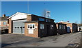
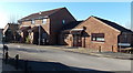
Royal Wootton Bassett Fire Station
Part of Wiltshire Fire & Rescue service, the fire station is located on the west side of Station Road.
Image: © Jaggery
Taken: 2 Feb 2013
0.15 miles