IMAGES TAKEN NEAR TO
Mill Close, SWINDON, SN4 0PL
Introduction
This page details the photographs taken nearby to Mill Close, SN4 0PL by members of the Geograph project.
The Geograph project started in 2005 with the aim of publishing, organising and preserving representative images for every square kilometre of Great Britain, Ireland and the Isle of Man.

There are currently over 7.5m images from over14,400 individuals and you can help contribute to the project by visiting https://www.geograph.org.uk
Image Map
Images are licensed for reuse under creativecommons.org/licenses/by-sa/2.0
Notes
- Clicking on the map will re-center to the selected point.
- The higher the marker number, the further away the image location is from the centre of the postcode.
Image Listing (90 Images Found)
Images are licensed for reuse under creativecommons.org/licenses/by-sa/2.0
Image
Details
Distance
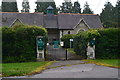
1
![Chiseldon features [6]](https://s2.geograph.org.uk/geophotos/06/42/67/6426746_3fbb7b9c_120x120.jpg)
Chiseldon features [6]
From Dewey Close the footpath runs to Butts Road. From the path is a gate into the cemetery.
Chiseldon village was founded by the Saxons and lies 3 miles south of Swindon on the Roman road from Cirencester and Mildenhall, now the A346. An agricultural village until the late 19th century but now most workers commute to Swindon. In 1914 a large military camp was built south of the village with the camp population being greater than that of the village. The military presence continued until 1961.
Image: © Michael Dibb
Taken: 11 Mar 2020
0.02 miles
2
![Chiseldon features [5]](https://s1.geograph.org.uk/geophotos/06/42/57/6425757_b6c432e9_120x120.jpg)
Chiseldon features [5]
The plaque on the millstone seen at Image
Chiseldon village was founded by the Saxons and lies 3 miles south of Swindon on the Roman road from Cirencester and Mildenhall, now the A346. An agricultural village until the late 19th century but now most workers commute to Swindon. In 1914 a large military camp was built south of the village with the camp population being greater than that of the village. The military presence continued until 1961.
Image: © Michael Dibb
Taken: 11 Mar 2020
0.02 miles
3
![Chiseldon features [4]](https://s2.geograph.org.uk/geophotos/06/42/57/6425754_18fa6b7a_120x120.jpg)
Chiseldon features [4]
Alongside the footpath that runs from Dewey Close to Butts Road stands this millstone. It is located near to where a brick tower windmill once stood. The plaque on the millstone reads
'Chiseldon Windmill
This Derbyshire Peak millstone stands adjacent to the site of the brick tower windmill, first built, it is believed in 1823.
By 1894 corn milling had ceased and by the turn of the century the mill had lost its machinery and sails. After a period as a water store the mill remained disused until 1983. Dismantled, relocated and then rebuilt, it now stands on Windmill Hill, six miles away to the west of Swindon.
The tower was presented to the St Martin's Property Group by the Borough of Thamesdown and the Parish of Chiseldon in 1983.'
The windmill is now located in the centre of Windmill Hill Business Park. There are a number of images of the mill at Image
Chiseldon village was founded by the Saxons and lies 3 miles south of Swindon on the Roman road from Cirencester and Mildenhall, now the A346. An agricultural village until the late 19th century but now most workers commute to Swindon. In 1914 a large military camp was built south of the village with the camp population being greater than that of the village. The military presence continued until 1961.
Image: © Michael Dibb
Taken: 11 Mar 2020
0.02 miles
4
![Chiseldon features [2]](https://s3.geograph.org.uk/geophotos/06/42/57/6425743_aa38bdb7_120x120.jpg)
Chiseldon features [2]
Seen from the footpath is this large electrical sub-station.
Chiseldon village was founded by the Saxons and lies 3 miles south of Swindon on the Roman road from Cirencester and Mildenhall, now the A346. An agricultural village until the late 19th century but now most workers commute to Swindon. In 1914 a large military camp was built south of the village with the camp population being greater than that of the village. The military presence continued until 1961.
Image: © Michael Dibb
Taken: 11 Mar 2020
0.02 miles
5
![Chiseldon features [3]](https://s1.geograph.org.uk/geophotos/06/42/57/6425745_d5d754dd_120x120.jpg)
Chiseldon features [3]
Seen from the footpath is this large electrical sub-station.
Chiseldon village was founded by the Saxons and lies 3 miles south of Swindon on the Roman road from Cirencester and Mildenhall, now the A346. An agricultural village until the late 19th century but now most workers commute to Swindon. In 1914 a large military camp was built south of the village with the camp population being greater than that of the village. The military presence continued until 1961.
Image: © Michael Dibb
Taken: 11 Mar 2020
0.02 miles
6
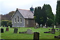
Chiseldon Museum, seen across cemetery
Image: © David Martin
Taken: 21 Oct 2016
0.04 miles
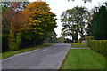
7
![Chiseldon ways [3]](https://s1.geograph.org.uk/geophotos/06/42/57/6425737_545d849c_120x120.jpg)
Chiseldon ways [3]
From Dewey Close this footpath runs past the cemetery to Butts Road.
Chiseldon village was founded by the Saxons and lies 3 miles south of Swindon on the Roman road from Cirencester and Mildenhall, now the A346. An agricultural village until the late 19th century but now most workers commute to Swindon. In 1914 a large military camp was built south of the village with the camp population being greater than that of the village. The military presence continued until 1961.
Image: © Michael Dibb
Taken: 11 Mar 2020
0.05 miles
8
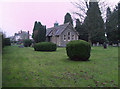
Chiseldon Museum, Butts Road, Chiseldon
Former chapel, now used as a museum.
Image: © Vieve Forward
Taken: 2 Jan 2013
0.05 miles