IMAGES TAKEN NEAR TO
Station Road, SWINDON, SN4 0PB
Introduction
This page details the photographs taken nearby to Station Road, SN4 0PB by members of the Geograph project.
The Geograph project started in 2005 with the aim of publishing, organising and preserving representative images for every square kilometre of Great Britain, Ireland and the Isle of Man.

There are currently over 7.5m images from over14,400 individuals and you can help contribute to the project by visiting https://www.geograph.org.uk
Image Map
Images are licensed for reuse under creativecommons.org/licenses/by-sa/2.0
Notes
- Clicking on the map will re-center to the selected point.
- The higher the marker number, the further away the image location is from the centre of the postcode.
Image Listing (96 Images Found)
Images are licensed for reuse under creativecommons.org/licenses/by-sa/2.0
Image
Details
Distance
1
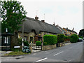
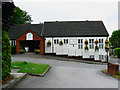
Station Road, Chiseldon
As might be inferred, this road once led to Chiseldon Station, an important stop on the old Midland and Southwestern Junction Railway (M&SWJR) which closed in 1961. The image shows a mix of traditional thatched cottages and local authority (or ex-local authority) houses built for the long-defunct Highworth Rural District Council, subsumed in 1974 into the then Thamesdown Borough Council, now Swindon Borough Council, a unitary authority.
Image: © Brian Robert Marshall
Taken: 5 Jun 2010
0.01 miles
2
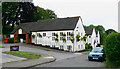
Landmark Hotel, Chiseldon (5)
Fifth of six images of the hotel which is likely to be demolished in the near future. Next image: http://www.geograph.org.uk/photo/1896588
NOTE! This image has a detailed ‘shared description’ which you won’t see by viewing this image on a slideshow. To read it click on the image.
Image: © Brian Robert Marshall
Taken: 5 Jun 2010
0.02 miles
3
![Chiseldon houses [5]](https://s0.geograph.org.uk/geophotos/06/42/57/6425700_c4982cec_120x120.jpg)
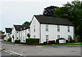
Chiseldon houses [5]
Tucked behind the hedge is this fine row of modernised 17th century thatched cottages at numbers 3 to 6 Station Road. The cottages are one bay each except for number 5 which is of two bays. A datestone on a chimney is 1678 or possibly 1618. Another view is at Image Listed, grade II, with details at: https://historicengland.org.uk/listing/the-list/list-entry/1355978
Chiseldon village was founded by the Saxons and lies 3 miles south of Swindon on the Roman road from Cirencester and Mildenhall, now the A346. An agricultural village until the late 19th century but now most workers commute to Swindon. In 1914 a large military camp was built south of the village with the camp population being greater than that of the village. The military presence continued until 1961.
Image: © Michael Dibb
Taken: 11 Mar 2020
0.02 miles
4
![Chiseldon houses [6]](https://s2.geograph.org.uk/geophotos/06/42/57/6425702_f3b17291_120x120.jpg)
Chiseldon houses [6]
This fine row of modernised 17th century thatched cottages is numbers 3 to 6 Station Road. The cottages are one bay each except for number 5 which is of two bays. A datestone on a chimney is 1678 or possibly 1618. Another view is at Image Listed, grade II, with details at: https://historicengland.org.uk/listing/the-list/list-entry/1355978
Chiseldon village was founded by the Saxons and lies 3 miles south of Swindon on the Roman road from Cirencester and Mildenhall, now the A346. An agricultural village until the late 19th century but now most workers commute to Swindon. In 1914 a large military camp was built south of the village with the camp population being greater than that of the village. The military presence continued until 1961.
Image: © Michael Dibb
Taken: 11 Mar 2020
0.02 miles
5
Landmark Hotel, Chiseldon (3)
Third of six images of the hotel which is likely to be demolished in the near future. Next image: http://www.geograph.org.uk/photo/1896584
NOTE! This image has a detailed ‘shared description’ which you won’t see by viewing this image on a slideshow. To read it click on the image.
Image: © Brian Robert Marshall
Taken: 5 Jun 2010
0.03 miles
6
Landmark Hotel, Chiseldon (4)
Fourth of six images of the hotel which is likely to be demolished in the near future. Next image: http://www.geograph.org.uk/photo/1896585
NOTE! This image has a detailed ‘shared description’ which you won’t see by viewing this image on a slideshow. To read it click on the image.
Image: © Brian Robert Marshall
Taken: 5 Jun 2010
0.03 miles
7
Landmark Hotel, Chiseldon (6)
Last of six images of the hotel which is likely to be demolished in the near future. First image: http://www.geograph.org.uk/photo/1896581
NOTE! This image has a detailed ‘shared description’ which you won’t see by viewing this image on a slideshow. To read it click on the image.
Image: © Brian Robert Marshall
Taken: 5 Jun 2010
0.03 miles
8
![Chiseldon buildings [5]](https://s0.geograph.org.uk/geophotos/06/42/57/6425716_cce60816_120x120.jpg)
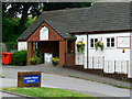
Chiseldon buildings [5]
This fine recent brick building is a doctors surgery.
Chiseldon village was founded by the Saxons and lies 3 miles south of Swindon on the Roman road from Cirencester and Mildenhall, now the A346. An agricultural village until the late 19th century but now most workers commute to Swindon. In 1914 a large military camp was built south of the village with the camp population being greater than that of the village. The military presence continued until 1961.
Image: © Michael Dibb
Taken: 11 Mar 2020
0.03 miles
9
![Chiseldon buildings [6]](https://s3.geograph.org.uk/geophotos/06/42/57/6425723_72a42ac3_120x120.jpg)
Chiseldon buildings [6]
Brian Robert Marshall took some images of the Landmark Hotel in 2010 Image when he wrote the following shared description. However the building remains and is seemingly closed and for sale.
Chiseldon village was founded by the Saxons and lies 3 miles south of Swindon on the Roman road from Cirencester and Mildenhall, now the A346. An agricultural village until the late 19th century but now most workers commute to Swindon. In 1914 a large military camp was built south of the village with the camp population being greater than that of the village. The military presence continued until 1961.
Image: © Michael Dibb
Taken: 11 Mar 2020
0.03 miles
10
Landmark Hotel, Chiseldon (1)
First of six images of the hotel which is likely to be demolished in the near future. Next image http://www.geograph.org.uk/photo/1896582
NOTE! This image has a detailed ‘shared description’ which you won’t see by viewing this image on a slideshow. To read it click on the image.
Image: © Brian Robert Marshall
Taken: 5 Jun 2010
0.03 miles