IMAGES TAKEN NEAR TO
Tatley Walk, SWINDON, SN4 0NX
Introduction
This page details the photographs taken nearby to Tatley Walk, SN4 0NX by members of the Geograph project.
The Geograph project started in 2005 with the aim of publishing, organising and preserving representative images for every square kilometre of Great Britain, Ireland and the Isle of Man.

There are currently over 7.5m images from over14,400 individuals and you can help contribute to the project by visiting https://www.geograph.org.uk
Image Map
Images are licensed for reuse under creativecommons.org/licenses/by-sa/2.0
Notes
- Clicking on the map will re-center to the selected point.
- The higher the marker number, the further away the image location is from the centre of the postcode.
Image Listing (43 Images Found)
Images are licensed for reuse under creativecommons.org/licenses/by-sa/2.0
Image
Details
Distance
2
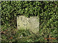
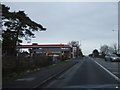
Old Milestone by the A346, Marlborough Road, Chiseldon
Swindon thin 'D' stone by the A346, in parish of Chiseldon (Swindon District), Marlborough Road; in front of Milestone bungalow, 100m South of Butt Road junction, in hedge, under silver birch, opposite speed camera.
Inscription once read:-
Swindon 4
(Marlboro 7)
Hungerford
14 Miles
London
79 Miles
Grade II listed.
List Entry Number: 1300123 https://historicengland.org.uk/listing/the-list/list-entry/1300123
Surveyed
Milestone Society National ID: WI_mlsn07
Image: © Milestone Society
Taken: 22 Mar 2004
0.12 miles
3
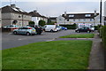
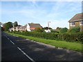
Castle View Road, Chiseldon
A road of originally local authority houses at the southeastern corner of the village. The view could be Liddington Castle or Barbury Castle depending on the direction you look in, but they probably had in mind the nearer Liddington Castle when they named the road. The castles are two of the iron age hill-forts that are dotted around the downs of Wessex.
Image: © Andrew Smith
Taken: 16 Feb 2008
0.12 miles
4
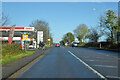
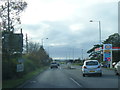
A346 Marlborough Road, Chiseldon
Towards Swindon.
Image: © Robin Webster
Taken: 9 Jan 2022
0.14 miles
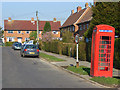
7
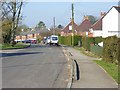
Station Road, Chiseldon
The name of the road is a reminder of the fact that Chiseldon was served by a railway station between 1881 and 1961. The line ran immediately to the left of this road and the station was located at its western end. We are looking towards the village centre and the church tower can just be seen.
Image: © Andrew Smith
Taken: 16 Feb 2008
0.17 miles
10
Junction of Butts Road and Marlborough Road
Image: © David Martin
Taken: 21 Oct 2016
0.18 miles